You are here: Home > Network List > YQ13 - Study of Extension and Magmatism in Malawi and Tanzania Stations List
> Station KIPE Kipengere,Tanzania > Earthquake Result Viewer
KIPE Kipengere,Tanzania - Earthquake Result Viewer
| Earthquake location: |
Northern Molucca Sea |
| Earthquake latitude/longitude: |
2.3/127.1 |
| Earthquake time(UTC): |
2014/11/21 (325) 10:10:19 GMT |
| Earthquake Depth: |
38 km |
| Earthquake Magnitude: |
6.5 MWC, 6.8 MI, 6.9 MI |
| Earthquake Catalog/Contributor: |
NEIC PDE/NEIC COMCAT |
|
| Network: |
YQ Study of Extension and Magmatism in Malawi and Tanzania |
| Station: |
KIPE Kipengere,Tanzania |
| Lat/Lon: |
9.29 S/34.44 E |
| Elevation: |
2224 m |
|
| Distance: |
92.9 deg |
| Az: |
260.866 deg |
| Baz: |
88.185 deg |
| Ray Param: |
0.04134413 |
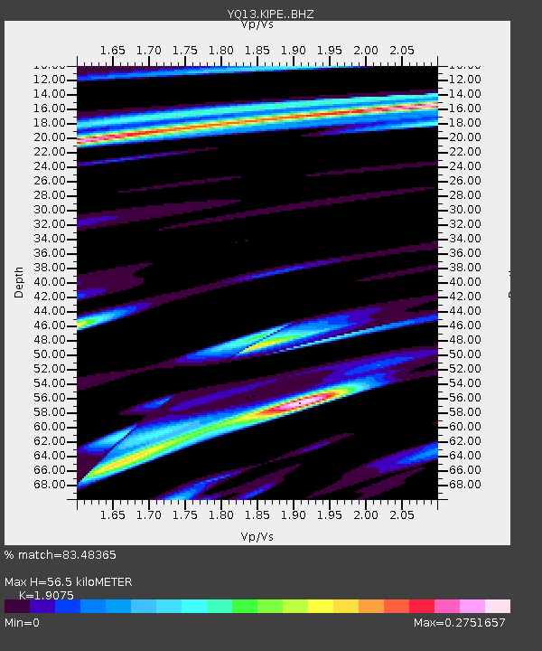
| Estimated Moho Depth: |
56.5 km |
| Estimated Crust Vp/Vs: |
1.91 |
| Assumed Crust Vp: |
6.576 km/s |
| Estimated Crust Vs: |
3.448 km/s |
| Estimated Crust Poisson's Ratio: |
0.31 |
|
| Radial Match: |
83.48365 % |
| Radial Bump: |
400 |
| Transverse Match: |
51.205704 % |
| Transverse Bump: |
400 |
| SOD ConfigId: |
3390531 |
| Insert Time: |
2019-04-15 03:41:36.817 +0000 |
| GWidth: |
2.5 |
| Max Bumps: |
400 |
| Tol: |
0.001 |
|

Signal To Noise
| Channel | StoN | STA | LTA |
| YQ:KIPE: :BHZ:20141121T10:22:57.709995Z | 16.827875 | 9.022569E-7 | 5.3616805E-8 |
| YQ:KIPE: :BHN:20141121T10:22:57.709995Z | 0.48708904 | 9.8823044E-8 | 2.0288496E-7 |
| YQ:KIPE: :BHE:20141121T10:22:57.709995Z | 2.3265848 | 3.5873444E-7 | 1.5418928E-7 |
| Arrivals |
| Ps | 8.0 SECOND |
| PpPs | 24 SECOND |
| PsPs/PpSs | 32 SECOND |


