You are here: Home > Network List > YQ13 - Study of Extension and Magmatism in Malawi and Tanzania Stations List
> Station MLOW Mlowe,Malawi > Earthquake Result Viewer
MLOW Mlowe,Malawi - Earthquake Result Viewer
| Earthquake location: |
Northern Molucca Sea |
| Earthquake latitude/longitude: |
2.3/127.1 |
| Earthquake time(UTC): |
2014/11/21 (325) 10:10:19 GMT |
| Earthquake Depth: |
38 km |
| Earthquake Magnitude: |
6.5 MWC, 6.8 MI, 6.9 MI |
| Earthquake Catalog/Contributor: |
NEIC PDE/NEIC COMCAT |
|
| Network: |
YQ Study of Extension and Magmatism in Malawi and Tanzania |
| Station: |
MLOW Mlowe,Malawi |
| Lat/Lon: |
10.78 S/34.21 E |
| Elevation: |
513 m |
|
| Distance: |
93.2 deg |
| Az: |
259.392 deg |
| Baz: |
88.304 deg |
| Ray Param: |
0.04129056 |
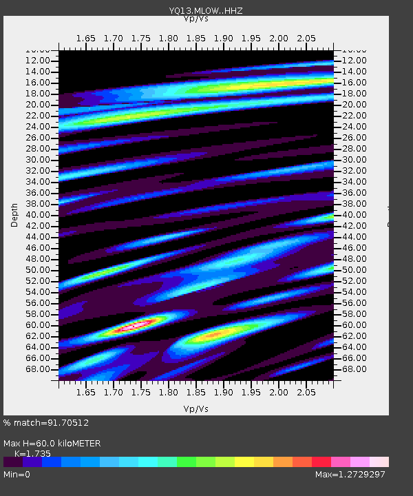
| Estimated Moho Depth: |
60.0 km |
| Estimated Crust Vp/Vs: |
1.74 |
| Assumed Crust Vp: |
6.502 km/s |
| Estimated Crust Vs: |
3.747 km/s |
| Estimated Crust Poisson's Ratio: |
0.25 |
|
| Radial Match: |
91.70512 % |
| Radial Bump: |
400 |
| Transverse Match: |
79.31296 % |
| Transverse Bump: |
400 |
| SOD ConfigId: |
3390531 |
| Insert Time: |
2019-04-15 03:41:41.370 +0000 |
| GWidth: |
2.5 |
| Max Bumps: |
400 |
| Tol: |
0.001 |
|

Signal To Noise
| Channel | StoN | STA | LTA |
| YQ:MLOW: :HHZ:20141121T10:22:58.939976Z | 11.660642 | 8.53474E-7 | 7.3192716E-8 |
| YQ:MLOW: :HHN:20141121T10:22:58.939976Z | 1.2149315 | 7.752218E-8 | 6.380786E-8 |
| YQ:MLOW: :HHE:20141121T10:22:58.939976Z | 4.592039 | 4.218293E-7 | 9.1861E-8 |
| Arrivals |
| Ps | 6.9 SECOND |
| PpPs | 25 SECOND |
| PsPs/PpSs | 32 SECOND |


