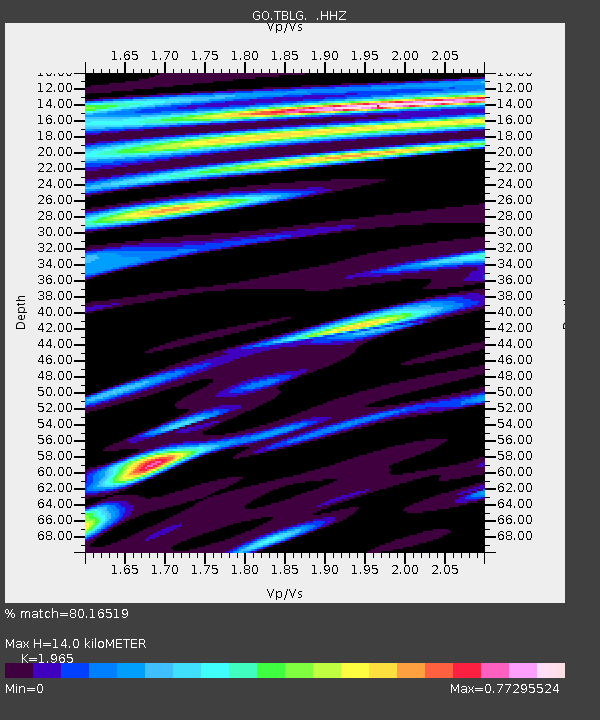
TBLG Delisi, Georgia - Earthquake Result Viewer

Earthquake location: Andreanof Islands, Aleutian Is.
Earthquake latitude/longitude: 51.6/-174.7
Earthquake time(UTC): 2013/09/15 (258) 16:21:37 GMT
Earthquake Depth: 24 km
Earthquake Magnitude: 6.1 MWW, 5.7 MI, 5.7 ML, 6.0 MWB, 6.1 MWC, 6.1 MWW
Earthquake Catalog/Contributor: NEIC PDE/NEIC COMCAT
Network: GO National Seismic Network of Georgia
Station: TBLG Delisi, Georgia
Lat/Lon: 41.73 N/44.74 E
Elevation: 510 m
Distance: 80.9 deg
Az: 331.207 deg
Baz: 23.676 deg
Ray Param: 0.047911428
Estimated Moho Depth: 14.0 km
Estimated Crust Vp/Vs: 1.97
Assumed Crust Vp: 6.291 km/s
Estimated Crust Vs: 3.201 km/s
Estimated Crust Poisson's Ratio: 0.33
Radial Match: 80.16519 %
Radial Bump: 400
Transverse Match: 85.45679 %
Transverse Bump: 400
SOD ConfigId: 626651
Insert Time: 2014-04-18 17:03:07.503 +0000
GWidth: 2.5
Max Bumps: 400
Tol: 0.001

Signal To Noise

ChannelStoNSTALTA
GO:TBLG: :HHZ:20130915T16:33:18.100012Z9.5309367.2250475E-77.580628E-8
GO:TBLG: :HHN:20130915T16:33:18.100012Z3.5298811.8121611E-75.133774E-8
GO:TBLG: :HHE:20130915T16:33:18.100012Z1.71557581.23687E-77.20965E-8
Arrivals
Ps2.2 SECOND
PpPs6.4 SECOND
PsPs/PpSs8.6 SECOND