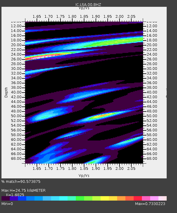
LSA Tibet, China - Earthquake Result Viewer
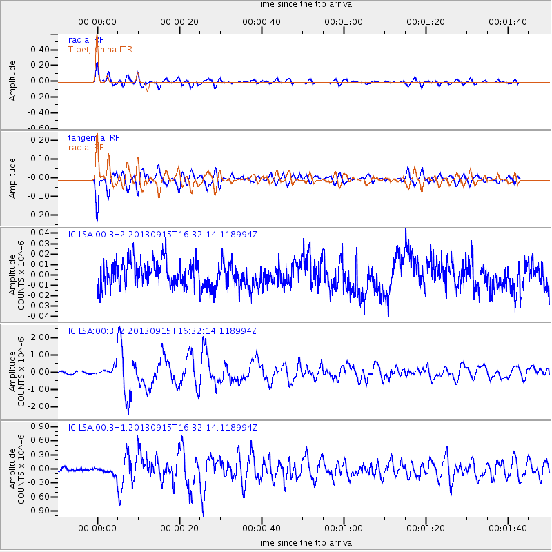
Earthquake location: Andreanof Islands, Aleutian Is.
Earthquake latitude/longitude: 51.6/-174.7
Earthquake time(UTC): 2013/09/15 (258) 16:21:37 GMT
Earthquake Depth: 24 km
Earthquake Magnitude: 6.1 MWW, 5.7 MI, 5.7 ML, 6.0 MWB, 6.1 MWC, 6.1 MWW
Earthquake Catalog/Contributor: NEIC PDE/NEIC COMCAT
Network: IC New China Digital Seismograph Network
Station: LSA Tibet, China
Lat/Lon: 29.70 N/91.13 E
Elevation: 3660 m
Distance: 69.8 deg
Az: 292.359 deg
Baz: 41.556 deg
Ray Param: 0.055399448
Estimated Moho Depth: 24.75 km
Estimated Crust Vp/Vs: 1.68
Assumed Crust Vp: 6.514 km/s
Estimated Crust Vs: 3.872 km/s
Estimated Crust Poisson's Ratio: 0.23
Radial Match: 90.573875 %
Radial Bump: 400
Transverse Match: 90.12545 %
Transverse Bump: 400
SOD ConfigId: 626651
Insert Time: 2014-04-18 17:04:27.825 +0000
GWidth: 2.5
Max Bumps: 400
Tol: 0.001

Signal To Noise

ChannelStoNSTALTA
IC:LSA:00:BHZ:20130915T16:32:14.118994Z7.97426653.7529833E-74.7063683E-8
IC:LSA:00:BH1:20130915T16:32:14.118994Z2.3076148.7553275E-83.794104E-8
IC:LSA:00:BH2:20130915T16:32:14.118994Z0.917145431.0635871E-81.1596711E-8
Arrivals
Ps2.7 SECOND
PpPs9.8 SECOND
PsPs/PpSs12 SECOND