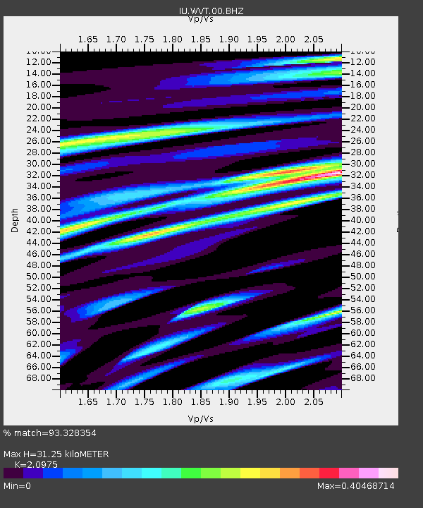
WVT Waverly, Tennessee, USA - Earthquake Result Viewer

Earthquake location: Andreanof Islands, Aleutian Is.
Earthquake latitude/longitude: 51.6/-174.7
Earthquake time(UTC): 2013/09/15 (258) 16:21:37 GMT
Earthquake Depth: 24 km
Earthquake Magnitude: 6.1 MWW, 5.7 MI, 5.7 ML, 6.0 MWB, 6.1 MWC, 6.1 MWW
Earthquake Catalog/Contributor: NEIC PDE/NEIC COMCAT
Network: IU Global Seismograph Network (GSN - IRIS/USGS)
Station: WVT Waverly, Tennessee, USA
Lat/Lon: 36.13 N/87.83 W
Elevation: 170 m
Distance: 60.9 deg
Az: 67.674 deg
Baz: 314.516 deg
Ray Param: 0.0611855
Estimated Moho Depth: 31.25 km
Estimated Crust Vp/Vs: 2.10
Assumed Crust Vp: 6.444 km/s
Estimated Crust Vs: 3.072 km/s
Estimated Crust Poisson's Ratio: 0.35
Radial Match: 93.328354 %
Radial Bump: 386
Transverse Match: 41.378044 %
Transverse Bump: 400
SOD ConfigId: 626651
Insert Time: 2014-04-18 17:07:03.375 +0000
GWidth: 2.5
Max Bumps: 400
Tol: 0.001

Signal To Noise

ChannelStoNSTALTA
IU:WVT:00:BHZ:20130915T16:31:16.918982Z5.8882028.8116656E-71.4964951E-7
IU:WVT:00:BH1:20130915T16:31:16.918982Z1.76034123.7334195E-72.12085E-7
IU:WVT:00:BH2:20130915T16:31:16.918982Z1.74861372.4305388E-71.3899805E-7
Arrivals
Ps5.5 SECOND
PpPs14 SECOND
PsPs/PpSs20 SECOND