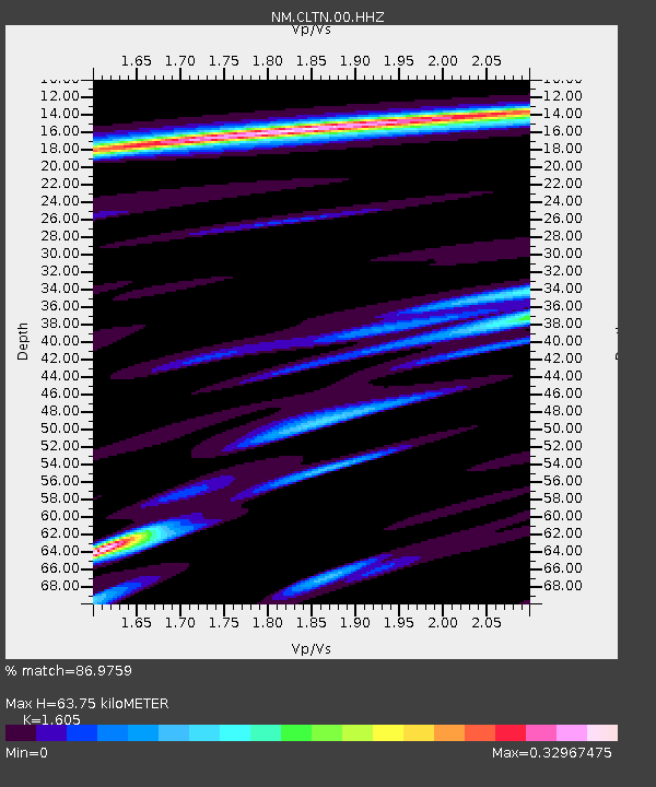
CLTN Cedars of Lebanon,TN - Earthquake Result Viewer

Earthquake location: Andreanof Islands, Aleutian Is.
Earthquake latitude/longitude: 51.6/-174.7
Earthquake time(UTC): 2013/09/15 (258) 16:21:37 GMT
Earthquake Depth: 24 km
Earthquake Magnitude: 6.1 MWW, 5.7 MI, 5.7 ML, 6.0 MWB, 6.1 MWC, 6.1 MWW
Earthquake Catalog/Contributor: NEIC PDE/NEIC COMCAT
Network: NM Cooperative New Madrid Seismic Network
Station: CLTN Cedars of Lebanon,TN
Lat/Lon: 36.09 N/86.33 W
Elevation: 208 m
Distance: 61.8 deg
Az: 66.732 deg
Baz: 314.943 deg
Ray Param: 0.060611237
Estimated Moho Depth: 63.75 km
Estimated Crust Vp/Vs: 1.61
Assumed Crust Vp: 6.444 km/s
Estimated Crust Vs: 4.015 km/s
Estimated Crust Poisson's Ratio: 0.18
Radial Match: 86.9759 %
Radial Bump: 259
Transverse Match: 73.3379 %
Transverse Bump: 400
SOD ConfigId: 626651
Insert Time: 2014-04-18 17:12:13.662 +0000
GWidth: 2.5
Max Bumps: 400
Tol: 0.001

Signal To Noise

ChannelStoNSTALTA
NM:CLTN:00:HHZ:20130915T16:31:22.915015Z9.1775949.606856E-71.04677284E-7
NM:CLTN:00:HHN:20130915T16:31:22.915015Z3.39914013.4418645E-71.0125691E-7
NM:CLTN:00:HHE:20130915T16:31:22.915015Z4.1271652.763944E-76.6969555E-8
Arrivals
Ps6.3 SECOND
PpPs25 SECOND
PsPs/PpSs31 SECOND