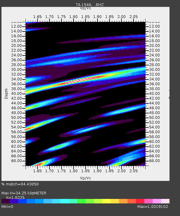
154A Montrose, GA, USA - Earthquake Result Viewer
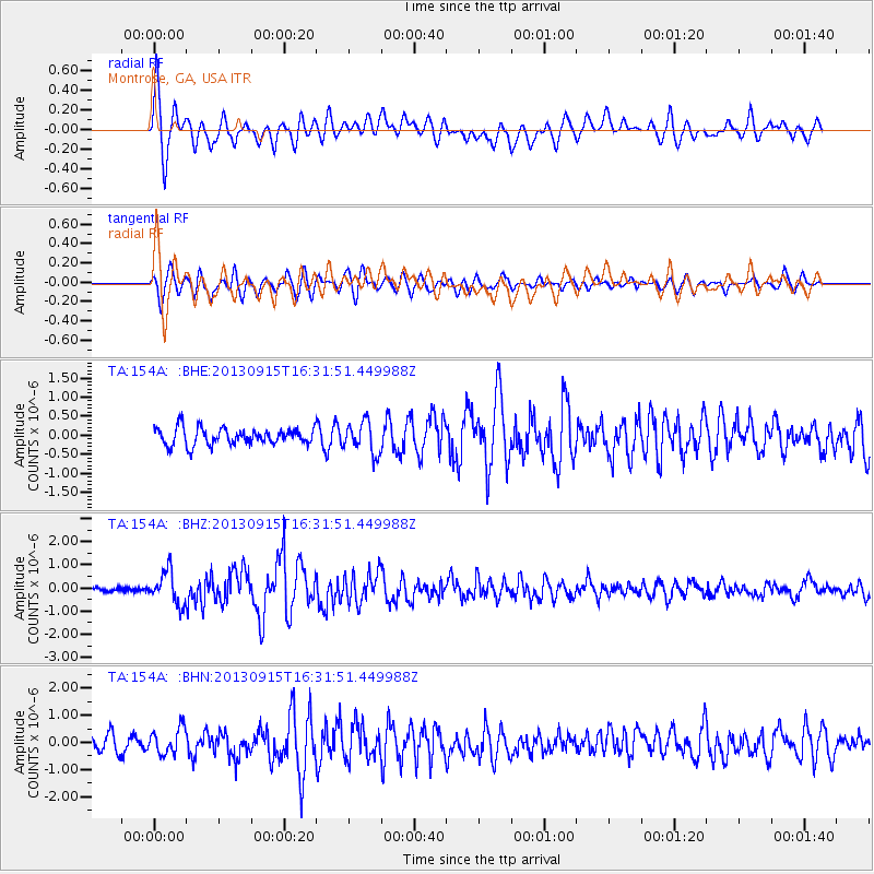
Earthquake location: Andreanof Islands, Aleutian Is.
Earthquake latitude/longitude: 51.6/-174.7
Earthquake time(UTC): 2013/09/15 (258) 16:21:37 GMT
Earthquake Depth: 24 km
Earthquake Magnitude: 6.1 MWW, 5.7 MI, 5.7 ML, 6.0 MWB, 6.1 MWC, 6.1 MWW
Earthquake Catalog/Contributor: NEIC PDE/NEIC COMCAT
Network: TA USArray Transportable Network (new EarthScope stations)
Station: 154A Montrose, GA, USA
Lat/Lon: 32.61 N/83.11 W
Elevation: 111 m
Distance: 66.2 deg
Az: 67.279 deg
Baz: 316.996 deg
Ray Param: 0.057774004
Estimated Moho Depth: 34.25 km
Estimated Crust Vp/Vs: 1.82
Assumed Crust Vp: 6.565 km/s
Estimated Crust Vs: 3.602 km/s
Estimated Crust Poisson's Ratio: 0.28
Radial Match: 84.43858 %
Radial Bump: 400
Transverse Match: 76.05661 %
Transverse Bump: 400
SOD ConfigId: 626651
Insert Time: 2014-04-18 17:18:35.358 +0000
GWidth: 2.5
Max Bumps: 400
Tol: 0.001

Signal To Noise

ChannelStoNSTALTA
TA:154A: :BHZ:20130915T16:31:51.449988Z6.15134437.043524E-71.1450382E-7
TA:154A: :BHN:20130915T16:31:51.449988Z1.88944674.787635E-72.533882E-7
TA:154A: :BHE:20130915T16:31:51.449988Z1.88869574.1297452E-72.1865593E-7
Arrivals
Ps4.5 SECOND
PpPs14 SECOND
PsPs/PpSs19 SECOND