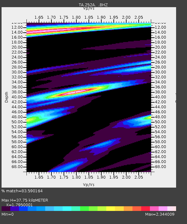
252A Lumpkin, GA, USA - Earthquake Result Viewer
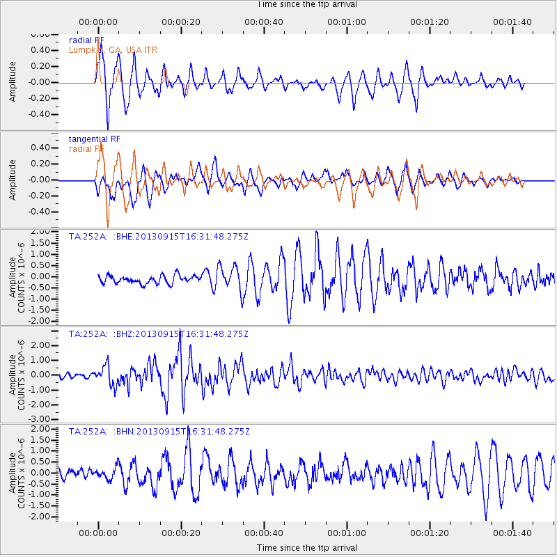
Earthquake location: Andreanof Islands, Aleutian Is.
Earthquake latitude/longitude: 51.6/-174.7
Earthquake time(UTC): 2013/09/15 (258) 16:21:37 GMT
Earthquake Depth: 24 km
Earthquake Magnitude: 6.1 MWW, 5.7 MI, 5.7 ML, 6.0 MWB, 6.1 MWC, 6.1 MWW
Earthquake Catalog/Contributor: NEIC PDE/NEIC COMCAT
Network: TA USArray Transportable Network (new EarthScope stations)
Station: 252A Lumpkin, GA, USA
Lat/Lon: 32.00 N/84.74 W
Elevation: 142 m
Distance: 65.7 deg
Az: 68.843 deg
Baz: 316.768 deg
Ray Param: 0.05809759
Estimated Moho Depth: 37.75 km
Estimated Crust Vp/Vs: 1.80
Assumed Crust Vp: 6.347 km/s
Estimated Crust Vs: 3.536 km/s
Estimated Crust Poisson's Ratio: 0.27
Radial Match: 83.590164 %
Radial Bump: 363
Transverse Match: 73.76102 %
Transverse Bump: 400
SOD ConfigId: 626651
Insert Time: 2014-04-18 17:18:52.900 +0000
GWidth: 2.5
Max Bumps: 400
Tol: 0.001

Signal To Noise

ChannelStoNSTALTA
TA:252A: :BHZ:20130915T16:31:48.275Z5.0266966.7439225E-71.3416212E-7
TA:252A: :BHN:20130915T16:31:48.275Z1.19742512.7182767E-72.2701018E-7
TA:252A: :BHE:20130915T16:31:48.275Z3.19499375.538685E-71.7335512E-7
Arrivals
Ps4.9 SECOND
PpPs16 SECOND
PsPs/PpSs21 SECOND