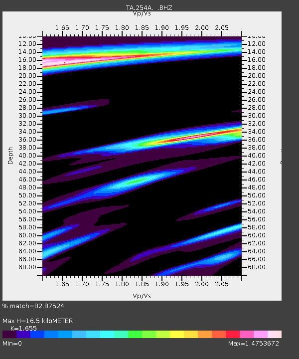
254A Abbeville, GA, USA - Earthquake Result Viewer
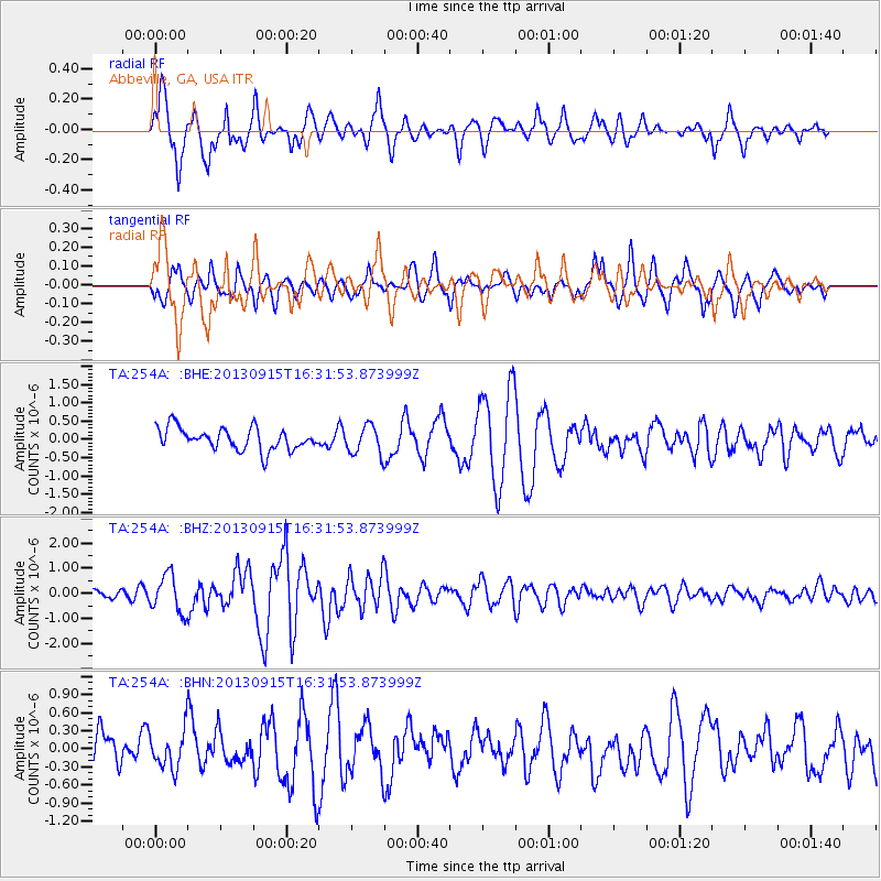
Earthquake location: Andreanof Islands, Aleutian Is.
Earthquake latitude/longitude: 51.6/-174.7
Earthquake time(UTC): 2013/09/15 (258) 16:21:37 GMT
Earthquake Depth: 24 km
Earthquake Magnitude: 6.1 MWW, 5.7 MI, 5.7 ML, 6.0 MWB, 6.1 MWC, 6.1 MWW
Earthquake Catalog/Contributor: NEIC PDE/NEIC COMCAT
Network: TA USArray Transportable Network (new EarthScope stations)
Station: 254A Abbeville, GA, USA
Lat/Lon: 31.95 N/83.29 W
Elevation: 78 m
Distance: 66.5 deg
Az: 67.899 deg
Baz: 317.147 deg
Ray Param: 0.057523783
Estimated Moho Depth: 16.5 km
Estimated Crust Vp/Vs: 1.65
Assumed Crust Vp: 6.565 km/s
Estimated Crust Vs: 3.966 km/s
Estimated Crust Poisson's Ratio: 0.21
Radial Match: 82.87524 %
Radial Bump: 400
Transverse Match: 61.92234 %
Transverse Bump: 400
SOD ConfigId: 626651
Insert Time: 2014-04-18 17:18:59.988 +0000
GWidth: 2.5
Max Bumps: 400
Tol: 0.001

Signal To Noise

ChannelStoNSTALTA
TA:254A: :BHZ:20130915T16:31:53.873999Z4.52849057.4067617E-71.6355916E-7
TA:254A: :BHN:20130915T16:31:53.873999Z1.07310933.0195633E-72.813845E-7
TA:254A: :BHE:20130915T16:31:53.873999Z1.30372363.8994304E-72.9909947E-7
Arrivals
Ps1.7 SECOND
PpPs6.4 SECOND
PsPs/PpSs8.1 SECOND