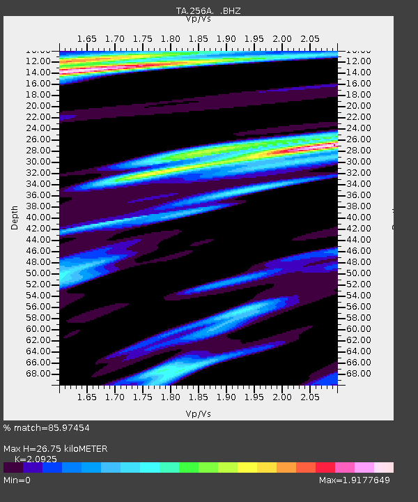
256A Glennville, GA, USA - Earthquake Result Viewer
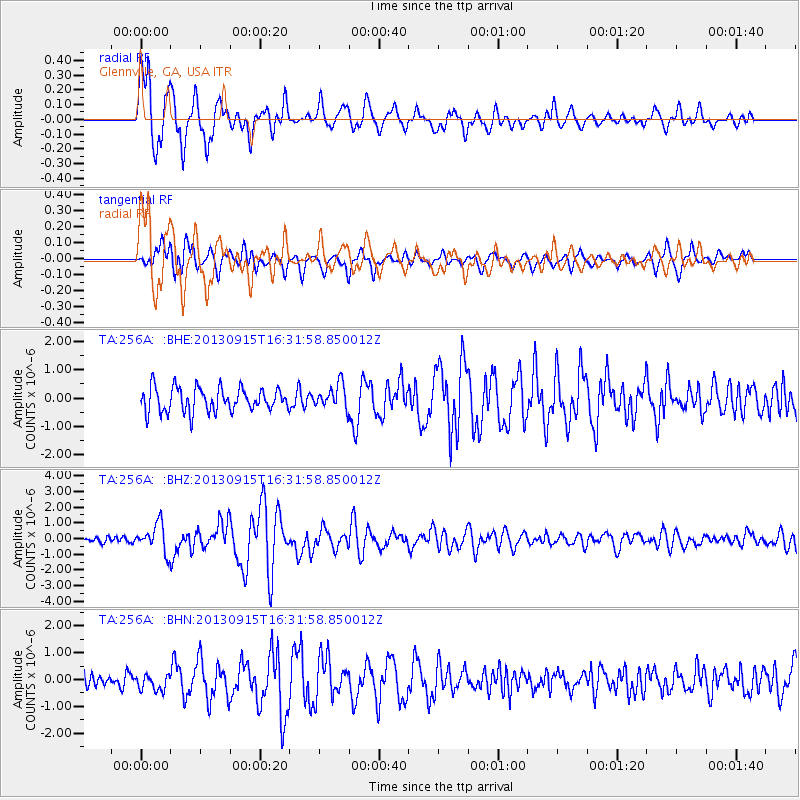
Earthquake location: Andreanof Islands, Aleutian Is.
Earthquake latitude/longitude: 51.6/-174.7
Earthquake time(UTC): 2013/09/15 (258) 16:21:37 GMT
Earthquake Depth: 24 km
Earthquake Magnitude: 6.1 MWW, 5.7 MI, 5.7 ML, 6.0 MWB, 6.1 MWC, 6.1 MWW
Earthquake Catalog/Contributor: NEIC PDE/NEIC COMCAT
Network: TA USArray Transportable Network (new EarthScope stations)
Station: 256A Glennville, GA, USA
Lat/Lon: 31.98 N/81.89 W
Elevation: 46 m
Distance: 67.3 deg
Az: 66.921 deg
Baz: 317.503 deg
Ray Param: 0.057006855
Estimated Moho Depth: 26.75 km
Estimated Crust Vp/Vs: 2.09
Assumed Crust Vp: 5.989 km/s
Estimated Crust Vs: 2.862 km/s
Estimated Crust Poisson's Ratio: 0.35
Radial Match: 85.97454 %
Radial Bump: 400
Transverse Match: 64.920525 %
Transverse Bump: 400
SOD ConfigId: 626651
Insert Time: 2014-04-18 17:19:04.420 +0000
GWidth: 2.5
Max Bumps: 400
Tol: 0.001

Signal To Noise

ChannelStoNSTALTA
TA:256A: :BHZ:20130915T16:31:58.850012Z5.35861978.9563787E-71.6713966E-7
TA:256A: :BHN:20130915T16:31:58.850012Z1.27051352.9421085E-72.3156845E-7
TA:256A: :BHE:20130915T16:31:58.850012Z1.0366524.335761E-74.1824654E-7
Arrivals
Ps5.0 SECOND
PpPs13 SECOND
PsPs/PpSs18 SECOND