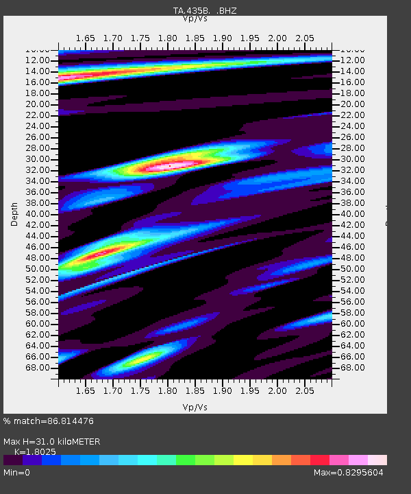
435B Jarrell, TX, USA - Earthquake Result Viewer

Earthquake location: Andreanof Islands, Aleutian Is.
Earthquake latitude/longitude: 51.6/-174.7
Earthquake time(UTC): 2013/09/15 (258) 16:21:37 GMT
Earthquake Depth: 24 km
Earthquake Magnitude: 6.1 MWW, 5.7 MI, 5.7 ML, 6.0 MWB, 6.1 MWC, 6.1 MWW
Earthquake Catalog/Contributor: NEIC PDE/NEIC COMCAT
Network: TA USArray Transportable Network (new EarthScope stations)
Station: 435B Jarrell, TX, USA
Lat/Lon: 30.78 N/97.58 W
Elevation: 248 m
Distance: 58.8 deg
Az: 78.676 deg
Baz: 314.684 deg
Ray Param: 0.06255358
Estimated Moho Depth: 31.0 km
Estimated Crust Vp/Vs: 1.80
Assumed Crust Vp: 6.347 km/s
Estimated Crust Vs: 3.521 km/s
Estimated Crust Poisson's Ratio: 0.28
Radial Match: 86.814476 %
Radial Bump: 392
Transverse Match: 84.99131 %
Transverse Bump: 400
SOD ConfigId: 626651
Insert Time: 2014-04-18 17:19:32.182 +0000
GWidth: 2.5
Max Bumps: 400
Tol: 0.001

Signal To Noise

ChannelStoNSTALTA
TA:435B: :BHZ:20130915T16:31:02.650Z4.7352434.0528485E-78.558903E-8
TA:435B: :BHN:20130915T16:31:02.650Z2.34684782.0718772E-78.828341E-8
TA:435B: :BHE:20130915T16:31:02.650Z0.962351861.1795142E-71.2256581E-7
Arrivals
Ps4.1 SECOND
PpPs13 SECOND
PsPs/PpSs17 SECOND