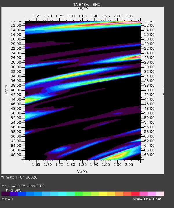
E48A Lockeyer, ON, CAN - Earthquake Result Viewer
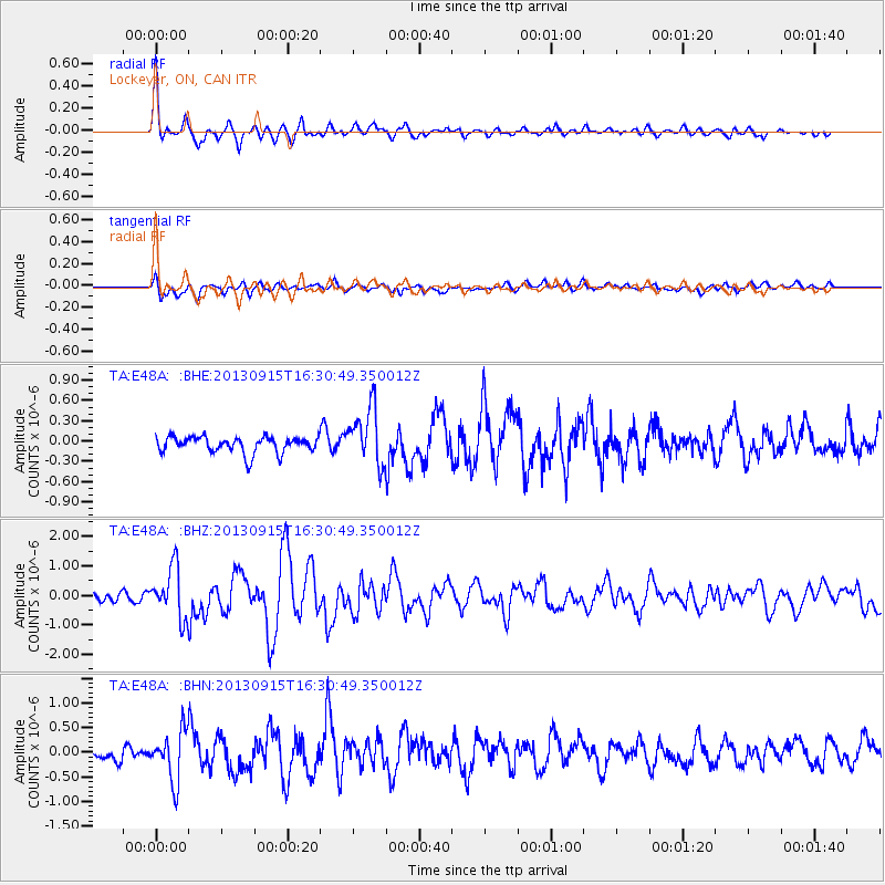
Earthquake location: Andreanof Islands, Aleutian Is.
Earthquake latitude/longitude: 51.6/-174.7
Earthquake time(UTC): 2013/09/15 (258) 16:21:37 GMT
Earthquake Depth: 24 km
Earthquake Magnitude: 6.1 MWW, 5.7 MI, 5.7 ML, 6.0 MWB, 6.1 MWC, 6.1 MWW
Earthquake Catalog/Contributor: NEIC PDE/NEIC COMCAT
Network: TA USArray Transportable Network (new EarthScope stations)
Station: E48A Lockeyer, ON, CAN
Lat/Lon: 46.48 N/82.17 W
Elevation: 347 m
Distance: 56.9 deg
Az: 55.463 deg
Baz: 311.934 deg
Ray Param: 0.06378285
Estimated Moho Depth: 10.25 km
Estimated Crust Vp/Vs: 2.10
Assumed Crust Vp: 6.467 km/s
Estimated Crust Vs: 3.087 km/s
Estimated Crust Poisson's Ratio: 0.35
Radial Match: 84.86626 %
Radial Bump: 400
Transverse Match: 63.490383 %
Transverse Bump: 400
SOD ConfigId: 626651
Insert Time: 2014-04-18 17:21:39.571 +0000
GWidth: 2.5
Max Bumps: 400
Tol: 0.001

Signal To Noise

ChannelStoNSTALTA
TA:E48A: :BHZ:20130915T16:30:49.350012Z4.6970378.544478E-71.8191207E-7
TA:E48A: :BHN:20130915T16:30:49.350012Z3.246785.055954E-71.5572209E-7
TA:E48A: :BHE:20130915T16:30:49.350012Z3.51491124.2125095E-71.1984682E-7
Arrivals
Ps1.8 SECOND
PpPs4.7 SECOND
PsPs/PpSs6.5 SECOND