F05D White Salmon, WA, USA - Earthquake Result Viewer
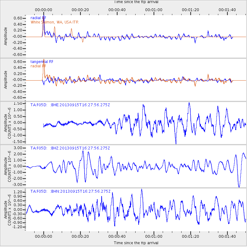
Earthquake location: Andreanof Islands, Aleutian Is.
Earthquake latitude/longitude: 51.6/-174.7
Earthquake time(UTC): 2013/09/15 (258) 16:21:37 GMT
Earthquake Depth: 24 km
Earthquake Magnitude: 6.1 MWW, 5.7 MI, 5.7 ML, 6.0 MWB, 6.1 MWC, 6.1 MWW
Earthquake Catalog/Contributor: NEIC PDE/NEIC COMCAT
Network: TA USArray Transportable Network (new EarthScope stations)
Station: F05D White Salmon, WA, USA
Lat/Lon: 45.89 N/121.46 W
Elevation: 472 m
Distance: 34.9 deg
Az: 77.894 deg
Baz: 299.127 deg
Ray Param: 0.07745718
Estimated Moho Depth: 15.0 km
Estimated Crust Vp/Vs: 1.66
Assumed Crust Vp: 6.597 km/s
Estimated Crust Vs: 3.974 km/s
Estimated Crust Poisson's Ratio: 0.22
Radial Match: 81.08109 %
Radial Bump: 400
Transverse Match: 69.30636 %
Transverse Bump: 400
SOD ConfigId: 626651
Insert Time: 2014-04-18 17:22:10.889 +0000
GWidth: 2.5
Max Bumps: 400
Tol: 0.001

Signal To Noise

ChannelStoNSTALTA
TA:F05D: :BHZ:20130915T16:27:56.275Z4.6397854.4317693E-79.55167E-8
TA:F05D: :BHN:20130915T16:27:56.275Z1.14461591.7559704E-71.5341134E-7
TA:F05D: :BHE:20130915T16:27:56.275Z1.59240281.7114736E-71.0747743E-7
Arrivals
Ps1.6 SECOND
PpPs5.5 SECOND
PsPs/PpSs7.2 SECOND