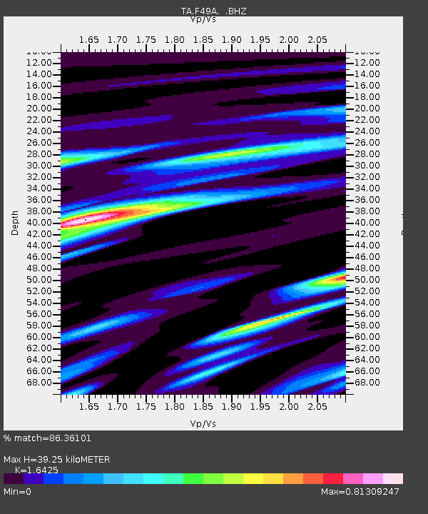
F49A Sandfield, ON, CAN - Earthquake Result Viewer
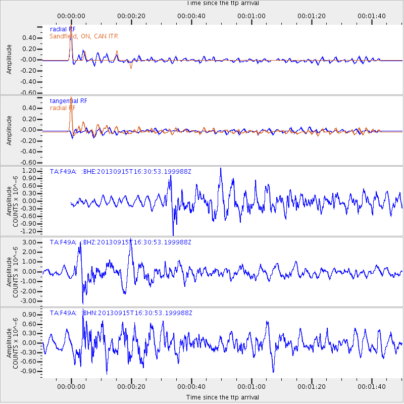
Earthquake location: Andreanof Islands, Aleutian Is.
Earthquake latitude/longitude: 51.6/-174.7
Earthquake time(UTC): 2013/09/15 (258) 16:21:37 GMT
Earthquake Depth: 24 km
Earthquake Magnitude: 6.1 MWW, 5.7 MI, 5.7 ML, 6.0 MWB, 6.1 MWC, 6.1 MWW
Earthquake Catalog/Contributor: NEIC PDE/NEIC COMCAT
Network: TA USArray Transportable Network (new EarthScope stations)
Station: F49A Sandfield, ON, CAN
Lat/Lon: 45.76 N/82.04 W
Elevation: 230 m
Distance: 57.5 deg
Az: 56.029 deg
Baz: 312.328 deg
Ray Param: 0.06343172
Estimated Moho Depth: 39.25 km
Estimated Crust Vp/Vs: 1.64
Assumed Crust Vp: 6.483 km/s
Estimated Crust Vs: 3.947 km/s
Estimated Crust Poisson's Ratio: 0.21
Radial Match: 86.36101 %
Radial Bump: 400
Transverse Match: 61.211273 %
Transverse Bump: 400
SOD ConfigId: 626651
Insert Time: 2014-04-18 17:22:20.381 +0000
GWidth: 2.5
Max Bumps: 400
Tol: 0.001

Signal To Noise

ChannelStoNSTALTA
TA:F49A: :BHZ:20130915T16:30:53.199988Z5.83746621.4088253E-62.4134192E-7
TA:F49A: :BHN:20130915T16:30:53.199988Z2.22082383.945682E-71.776675E-7
TA:F49A: :BHE:20130915T16:30:53.199988Z4.04818735.0353435E-71.2438514E-7
Arrivals
Ps4.1 SECOND
PpPs15 SECOND
PsPs/PpSs19 SECOND