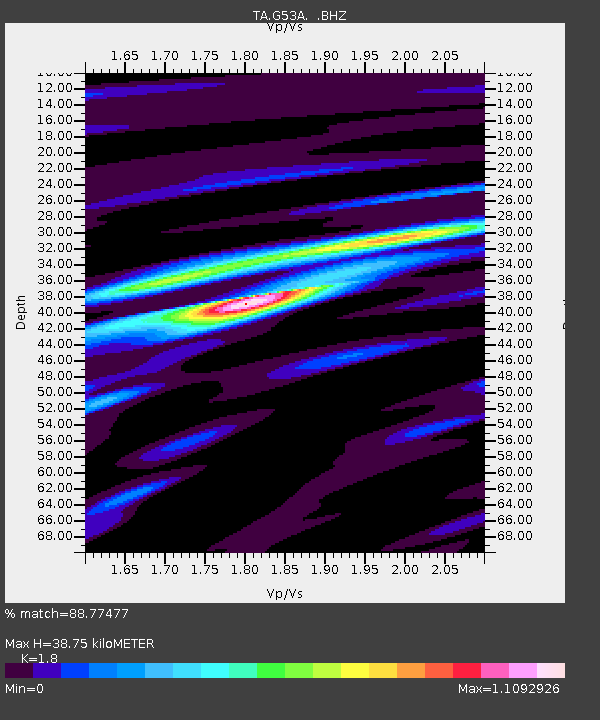
G53A Haliburton, ON, CAN - Earthquake Result Viewer

Earthquake location: Andreanof Islands, Aleutian Is.
Earthquake latitude/longitude: 51.6/-174.7
Earthquake time(UTC): 2013/09/15 (258) 16:21:37 GMT
Earthquake Depth: 24 km
Earthquake Magnitude: 6.1 MWW, 5.7 MI, 5.7 ML, 6.0 MWB, 6.1 MWC, 6.1 MWW
Earthquake Catalog/Contributor: NEIC PDE/NEIC COMCAT
Network: TA USArray Transportable Network (new EarthScope stations)
Station: G53A Haliburton, ON, CAN
Lat/Lon: 45.12 N/78.62 W
Elevation: 333 m
Distance: 59.7 deg
Az: 54.646 deg
Baz: 314.035 deg
Ray Param: 0.062001266
Estimated Moho Depth: 38.75 km
Estimated Crust Vp/Vs: 1.80
Assumed Crust Vp: 6.577 km/s
Estimated Crust Vs: 3.654 km/s
Estimated Crust Poisson's Ratio: 0.28
Radial Match: 88.77477 %
Radial Bump: 385
Transverse Match: 66.64239 %
Transverse Bump: 400
SOD ConfigId: 626651
Insert Time: 2014-04-18 17:23:04.357 +0000
GWidth: 2.5
Max Bumps: 400
Tol: 0.001

Signal To Noise

ChannelStoNSTALTA
TA:G53A: :BHZ:20130915T16:31:08.425024Z8.2146671.6211155E-61.9734402E-7
TA:G53A: :BHN:20130915T16:31:08.425024Z3.3050265.752899E-71.7406516E-7
TA:G53A: :BHE:20130915T16:31:08.425024Z7.7594356.764464E-78.717727E-8
Arrivals
Ps4.9 SECOND
PpPs16 SECOND
PsPs/PpSs21 SECOND