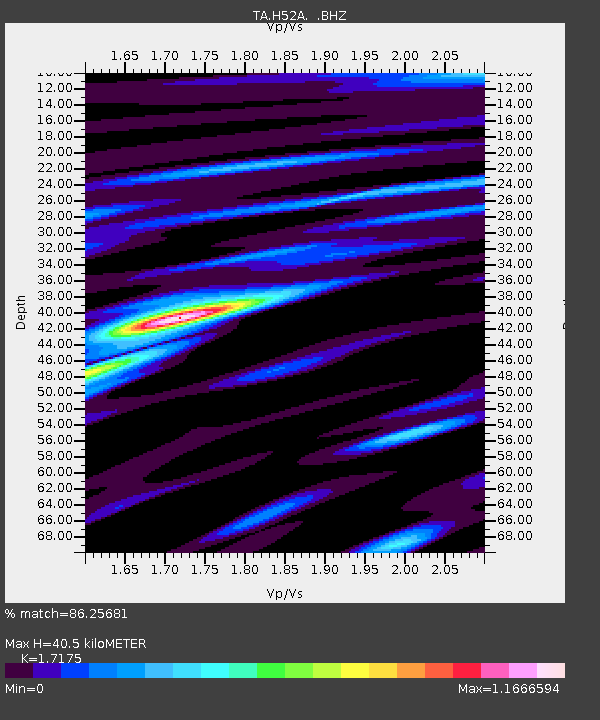
H52A Wyevale, ON, CAN - Earthquake Result Viewer

Earthquake location: Andreanof Islands, Aleutian Is.
Earthquake latitude/longitude: 51.6/-174.7
Earthquake time(UTC): 2013/09/15 (258) 16:21:37 GMT
Earthquake Depth: 24 km
Earthquake Magnitude: 6.1 MWW, 5.7 MI, 5.7 ML, 6.0 MWB, 6.1 MWC, 6.1 MWW
Earthquake Catalog/Contributor: NEIC PDE/NEIC COMCAT
Network: TA USArray Transportable Network (new EarthScope stations)
Station: H52A Wyevale, ON, CAN
Lat/Lon: 44.64 N/79.89 W
Elevation: 209 m
Distance: 59.4 deg
Az: 55.771 deg
Baz: 313.716 deg
Ray Param: 0.062209003
Estimated Moho Depth: 40.5 km
Estimated Crust Vp/Vs: 1.72
Assumed Crust Vp: 6.577 km/s
Estimated Crust Vs: 3.829 km/s
Estimated Crust Poisson's Ratio: 0.24
Radial Match: 86.25681 %
Radial Bump: 400
Transverse Match: 76.1487 %
Transverse Bump: 400
SOD ConfigId: 626651
Insert Time: 2014-04-18 17:23:45.054 +0000
GWidth: 2.5
Max Bumps: 400
Tol: 0.001

Signal To Noise

ChannelStoNSTALTA
TA:H52A: :BHZ:20130915T16:31:06.275Z7.1387471.3541389E-61.8968859E-7
TA:H52A: :BHN:20130915T16:31:06.275Z4.0116567.1799343E-71.7897682E-7
TA:H52A: :BHE:20130915T16:31:06.275Z3.22951224.6142054E-71.4287623E-7
Arrivals
Ps4.7 SECOND
PpPs16 SECOND
PsPs/PpSs21 SECOND