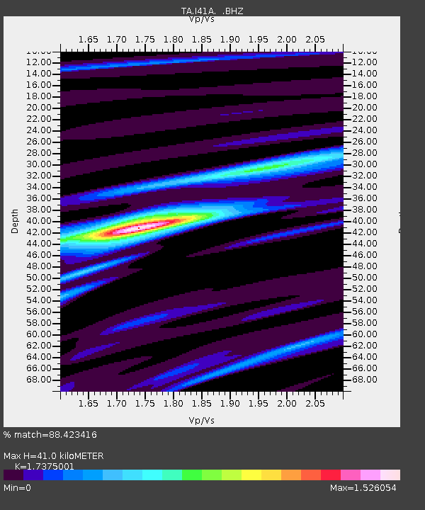
I41A Arkdale, WI, USA - Earthquake Result Viewer
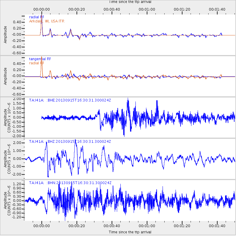
Earthquake location: Andreanof Islands, Aleutian Is.
Earthquake latitude/longitude: 51.6/-174.7
Earthquake time(UTC): 2013/09/15 (258) 16:21:37 GMT
Earthquake Depth: 24 km
Earthquake Magnitude: 6.1 MWW, 5.7 MI, 5.7 ML, 6.0 MWB, 6.1 MWC, 6.1 MWW
Earthquake Catalog/Contributor: NEIC PDE/NEIC COMCAT
Network: TA USArray Transportable Network (new EarthScope stations)
Station: I41A Arkdale, WI, USA
Lat/Lon: 44.06 N/89.87 W
Elevation: 289 m
Distance: 54.4 deg
Az: 61.996 deg
Baz: 310.16 deg
Ray Param: 0.06542822
Estimated Moho Depth: 41.0 km
Estimated Crust Vp/Vs: 1.74
Assumed Crust Vp: 6.41 km/s
Estimated Crust Vs: 3.689 km/s
Estimated Crust Poisson's Ratio: 0.25
Radial Match: 88.423416 %
Radial Bump: 357
Transverse Match: 57.07915 %
Transverse Bump: 400
SOD ConfigId: 626651
Insert Time: 2014-04-18 17:24:10.940 +0000
GWidth: 2.5
Max Bumps: 400
Tol: 0.001

Signal To Noise

ChannelStoNSTALTA
TA:I41A: :BHZ:20130915T16:30:31.300024Z5.7096931.127637E-61.9749521E-7
TA:I41A: :BHN:20130915T16:30:31.300024Z2.72294124.520782E-71.660257E-7
TA:I41A: :BHE:20130915T16:30:31.300024Z4.4910135.2654485E-71.17244106E-7
Arrivals
Ps5.0 SECOND
PpPs17 SECOND
PsPs/PpSs22 SECOND