You are here: Home > Network List > TA - USArray Transportable Network (new EarthScope stations) Stations List
> Station I45A Fountain, MI, USA > Earthquake Result Viewer
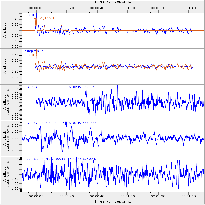
I45A Fountain, MI, USA - Earthquake Result Viewer
*The percent match for this event was below the threshold and hence no stack was calculated.
| Earthquake location: |
Andreanof Islands, Aleutian Is. |
| Earthquake latitude/longitude: |
51.6/-174.7 |
| Earthquake time(UTC): |
2013/09/15 (258) 16:21:37 GMT |
| Earthquake Depth: |
24 km |
| Earthquake Magnitude: |
6.1 MWW, 5.7 MI, 5.7 ML, 6.0 MWB, 6.1 MWC, 6.1 MWW |
| Earthquake Catalog/Contributor: |
NEIC PDE/NEIC COMCAT |
|
| Network: |
TA USArray Transportable Network (new EarthScope stations) |
| Station: |
I45A Fountain, MI, USA |
| Lat/Lon: |
44.04 N/86.23 W |
| Elevation: |
215 m |
|
| Distance: |
56.4 deg |
| Az: |
59.936 deg |
| Baz: |
311.509 deg |
| Ray Param: |
$rayparam |
*The percent match for this event was below the threshold and hence was not used in the summary stack. |
|
| Radial Match: |
75.49238 % |
| Radial Bump: |
400 |
| Transverse Match: |
55.050716 % |
| Transverse Bump: |
400 |
| SOD ConfigId: |
626651 |
| Insert Time: |
2014-04-18 17:24:17.909 +0000 |
| GWidth: |
2.5 |
| Max Bumps: |
400 |
| Tol: |
0.001 |
|
Signal To Noise
| Channel | StoN | STA | LTA |
| TA:I45A: :BHZ:20130915T16:30:45.675024Z | 4.9092493 | 1.1020662E-6 | 2.2448774E-7 |
| TA:I45A: :BHN:20130915T16:30:45.675024Z | 1.7407508 | 4.995362E-7 | 2.8696596E-7 |
| TA:I45A: :BHE:20130915T16:30:45.675024Z | 2.2475374 | 6.53091E-7 | 2.9058072E-7 |
| Arrivals |
| Ps | |
| PpPs | |
| PsPs/PpSs | |


