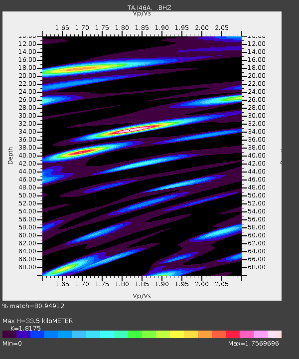
I46A Reed City, MI, USA - Earthquake Result Viewer

Earthquake location: Andreanof Islands, Aleutian Is.
Earthquake latitude/longitude: 51.6/-174.7
Earthquake time(UTC): 2013/09/15 (258) 16:21:37 GMT
Earthquake Depth: 24 km
Earthquake Magnitude: 6.1 MWW, 5.7 MI, 5.7 ML, 6.0 MWB, 6.1 MWC, 6.1 MWW
Earthquake Catalog/Contributor: NEIC PDE/NEIC COMCAT
Network: TA USArray Transportable Network (new EarthScope stations)
Station: I46A Reed City, MI, USA
Lat/Lon: 43.94 N/85.45 W
Elevation: 359 m
Distance: 56.9 deg
Az: 59.568 deg
Baz: 311.853 deg
Ray Param: 0.063803576
Estimated Moho Depth: 33.5 km
Estimated Crust Vp/Vs: 1.82
Assumed Crust Vp: 6.483 km/s
Estimated Crust Vs: 3.567 km/s
Estimated Crust Poisson's Ratio: 0.28
Radial Match: 80.94912 %
Radial Bump: 400
Transverse Match: 57.367348 %
Transverse Bump: 400
SOD ConfigId: 626651
Insert Time: 2014-04-18 17:24:26.697 +0000
GWidth: 2.5
Max Bumps: 400
Tol: 0.001

Signal To Noise

ChannelStoNSTALTA
TA:I46A: :BHZ:20130915T16:30:49.123999Z6.77681.4469948E-62.1352184E-7
TA:I46A: :BHN:20130915T16:30:49.123999Z1.74364617.1848007E-74.120561E-7
TA:I46A: :BHE:20130915T16:30:49.123999Z2.06735097.090219E-73.4296158E-7
Arrivals
Ps4.4 SECOND
PpPs14 SECOND
PsPs/PpSs18 SECOND