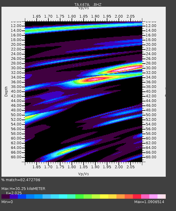
K47A Vremontville, MI, USA - Earthquake Result Viewer

Earthquake location: Andreanof Islands, Aleutian Is.
Earthquake latitude/longitude: 51.6/-174.7
Earthquake time(UTC): 2013/09/15 (258) 16:21:37 GMT
Earthquake Depth: 24 km
Earthquake Magnitude: 6.1 MWW, 5.7 MI, 5.7 ML, 6.0 MWB, 6.1 MWC, 6.1 MWW
Earthquake Catalog/Contributor: NEIC PDE/NEIC COMCAT
Network: TA USArray Transportable Network (new EarthScope stations)
Station: K47A Vremontville, MI, USA
Lat/Lon: 42.67 N/85.00 W
Elevation: 275 m
Distance: 58.0 deg
Az: 60.423 deg
Baz: 312.619 deg
Ray Param: 0.06309786
Estimated Moho Depth: 30.25 km
Estimated Crust Vp/Vs: 2.03
Assumed Crust Vp: 6.483 km/s
Estimated Crust Vs: 3.201 km/s
Estimated Crust Poisson's Ratio: 0.34
Radial Match: 82.472786 %
Radial Bump: 400
Transverse Match: 65.77677 %
Transverse Bump: 400
SOD ConfigId: 626651
Insert Time: 2014-04-18 17:26:08.615 +0000
GWidth: 2.5
Max Bumps: 400
Tol: 0.001

Signal To Noise

ChannelStoNSTALTA
TA:K47A: :BHZ:20130915T16:30:56.824988Z5.7818971.1783543E-62.0380062E-7
TA:K47A: :BHN:20130915T16:30:56.824988Z1.97865713.7309857E-71.885615E-7
TA:K47A: :BHE:20130915T16:30:56.824988Z2.7492475.4326966E-71.9760671E-7
Arrivals
Ps5.0 SECOND
PpPs14 SECOND
PsPs/PpSs19 SECOND