L44A Lake County Forest Preserve, Grayslake, IL, USA - Earthquake Result Viewer
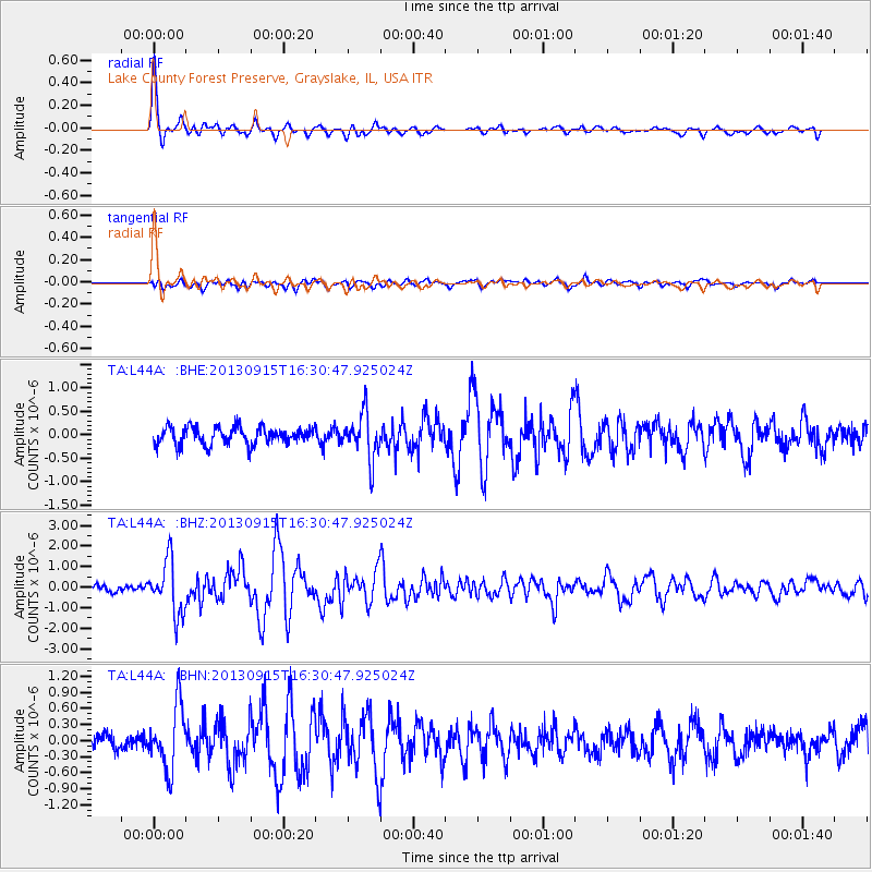
Earthquake location: Andreanof Islands, Aleutian Is.
Earthquake latitude/longitude: 51.6/-174.7
Earthquake time(UTC): 2013/09/15 (258) 16:21:37 GMT
Earthquake Depth: 24 km
Earthquake Magnitude: 6.1 MWW, 5.7 MI, 5.7 ML, 6.0 MWB, 6.1 MWC, 6.1 MWW
Earthquake Catalog/Contributor: NEIC PDE/NEIC COMCAT
Network: TA USArray Transportable Network (new EarthScope stations)
Station: L44A Lake County Forest Preserve, Grayslake, IL, USA
Lat/Lon: 42.18 N/87.91 W
Elevation: 202 m
Distance: 56.7 deg
Az: 62.576 deg
Baz: 311.822 deg
Ray Param: 0.063915774
Estimated Moho Depth: 41.0 km
Estimated Crust Vp/Vs: 1.63
Assumed Crust Vp: 6.483 km/s
Estimated Crust Vs: 3.965 km/s
Estimated Crust Poisson's Ratio: 0.20
Radial Match: 88.2736 %
Radial Bump: 325
Transverse Match: 61.27673 %
Transverse Bump: 400
SOD ConfigId: 626651
Insert Time: 2014-04-18 17:26:56.437 +0000
GWidth: 2.5
Max Bumps: 400
Tol: 0.001

Signal To Noise

ChannelStoNSTALTA
TA:L44A: :BHZ:20130915T16:30:47.925024Z6.1300391.3082861E-62.1342213E-7
TA:L44A: :BHN:20130915T16:30:47.925024Z2.94215775.8422927E-71.985717E-7
TA:L44A: :BHE:20130915T16:30:47.925024Z2.7375575.081337E-71.8561576E-7
Arrivals
Ps4.2 SECOND
PpPs16 SECOND
PsPs/PpSs20 SECOND