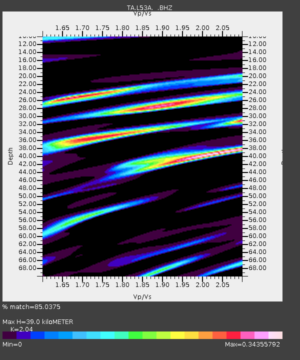
L53A Girard, PA, USA - Earthquake Result Viewer

Earthquake location: Andreanof Islands, Aleutian Is.
Earthquake latitude/longitude: 51.6/-174.7
Earthquake time(UTC): 2013/09/15 (258) 16:21:37 GMT
Earthquake Depth: 24 km
Earthquake Magnitude: 6.1 MWW, 5.7 MI, 5.7 ML, 6.0 MWB, 6.1 MWC, 6.1 MWW
Earthquake Catalog/Contributor: NEIC PDE/NEIC COMCAT
Network: TA USArray Transportable Network (new EarthScope stations)
Station: L53A Girard, PA, USA
Lat/Lon: 41.95 N/80.26 W
Elevation: 355 m
Distance: 61.0 deg
Az: 58.209 deg
Baz: 314.675 deg
Ray Param: 0.061104532
Estimated Moho Depth: 39.0 km
Estimated Crust Vp/Vs: 2.04
Assumed Crust Vp: 6.483 km/s
Estimated Crust Vs: 3.178 km/s
Estimated Crust Poisson's Ratio: 0.34
Radial Match: 85.0375 %
Radial Bump: 360
Transverse Match: 48.524292 %
Transverse Bump: 400
SOD ConfigId: 626651
Insert Time: 2014-04-18 17:27:12.248 +0000
GWidth: 2.5
Max Bumps: 400
Tol: 0.001

Signal To Noise

ChannelStoNSTALTA
TA:L53A: :BHZ:20130915T16:31:17.749976Z7.6667411.5162822E-61.9777403E-7
TA:L53A: :BHN:20130915T16:31:17.749976Z1.96460935.6213935E-72.861329E-7
TA:L53A: :BHE:20130915T16:31:17.749976Z2.97429254.778317E-71.606539E-7
Arrivals
Ps6.5 SECOND
PpPs18 SECOND
PsPs/PpSs24 SECOND