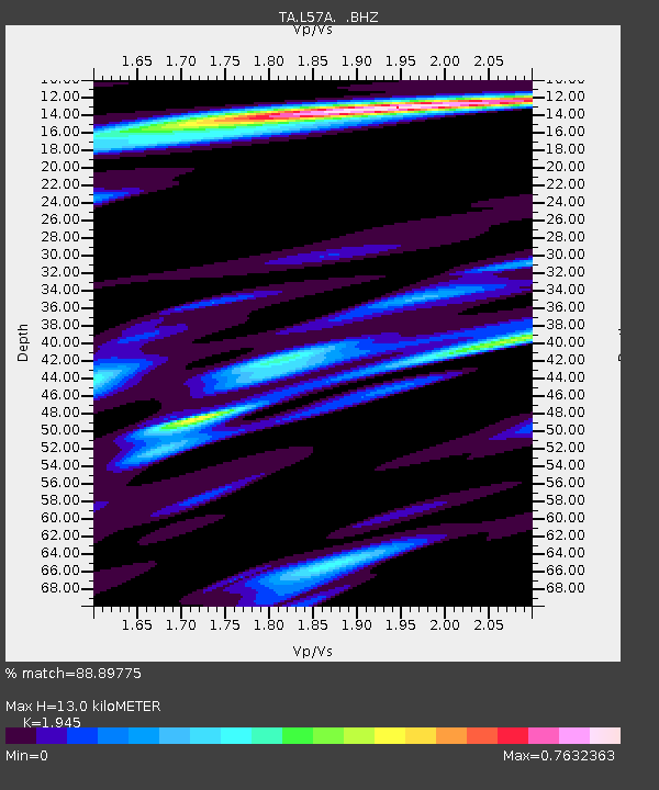
L57A Andrews Acres Farm, Gillet, PA, USA - Earthquake Result Viewer

Earthquake location: Andreanof Islands, Aleutian Is.
Earthquake latitude/longitude: 51.6/-174.7
Earthquake time(UTC): 2013/09/15 (258) 16:21:37 GMT
Earthquake Depth: 24 km
Earthquake Magnitude: 6.1 MWW, 5.7 MI, 5.7 ML, 6.0 MWB, 6.1 MWC, 6.1 MWW
Earthquake Catalog/Contributor: NEIC PDE/NEIC COMCAT
Network: TA USArray Transportable Network (new EarthScope stations)
Station: L57A Andrews Acres Farm, Gillet, PA, USA
Lat/Lon: 42.00 N/76.85 W
Elevation: 546 m
Distance: 62.8 deg
Az: 56.122 deg
Baz: 315.965 deg
Ray Param: 0.0599647
Estimated Moho Depth: 13.0 km
Estimated Crust Vp/Vs: 1.95
Assumed Crust Vp: 6.476 km/s
Estimated Crust Vs: 3.33 km/s
Estimated Crust Poisson's Ratio: 0.32
Radial Match: 88.89775 %
Radial Bump: 400
Transverse Match: 78.39997 %
Transverse Bump: 400
SOD ConfigId: 626651
Insert Time: 2014-04-18 17:27:26.215 +0000
GWidth: 2.5
Max Bumps: 400
Tol: 0.001

Signal To Noise

ChannelStoNSTALTA
TA:L57A: :BHZ:20130915T16:31:29.525Z11.1380842.1072697E-61.8919498E-7
TA:L57A: :BHN:20130915T16:31:29.525Z3.28741126.114677E-71.860028E-7
TA:L57A: :BHE:20130915T16:31:29.525Z6.20010767.499433E-71.209565E-7
Arrivals
Ps2.0 SECOND
PpPs5.7 SECOND
PsPs/PpSs7.7 SECOND