You are here: Home > Network List > CI - Caltech Regional Seismic Network Stations List
> Station TIN Tinemaha, California, USA > Earthquake Result Viewer
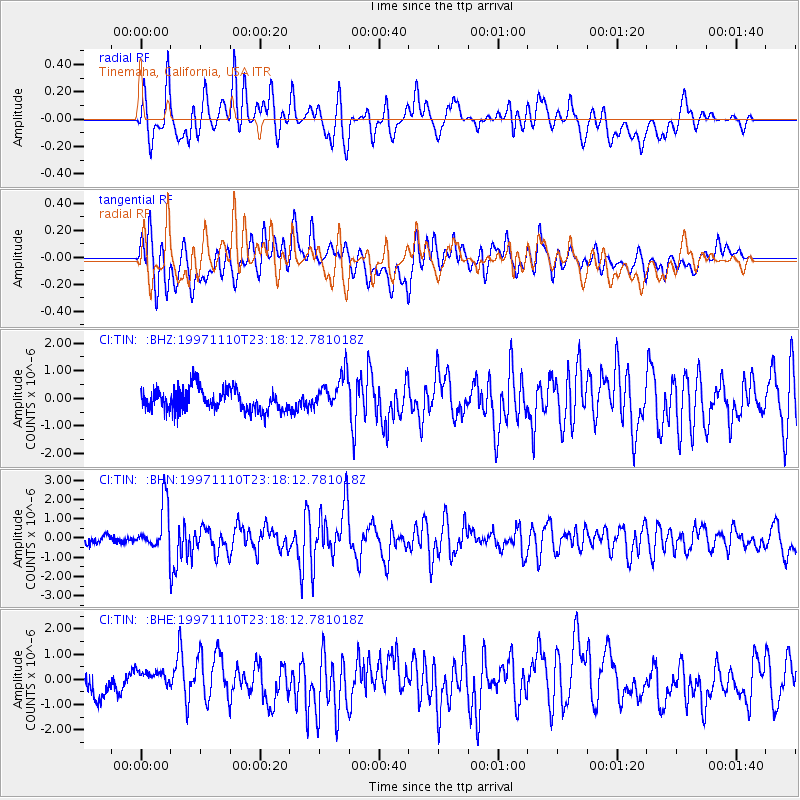
TIN Tinemaha, California, USA - Earthquake Result Viewer
*The percent match for this event was below the threshold and hence no stack was calculated.
| Earthquake location: |
Southeast Of Honshu, Japan |
| Earthquake latitude/longitude: |
31.2/140.5 |
| Earthquake time(UTC): |
1997/11/10 (314) 23:06:44 GMT |
| Earthquake Depth: |
86 km |
| Earthquake Magnitude: |
5.8 MB, 6.1 UNKNOWN, 6.1 MW |
| Earthquake Catalog/Contributor: |
WHDF/NEIC |
|
| Network: |
CI Caltech Regional Seismic Network |
| Station: |
TIN Tinemaha, California, USA |
| Lat/Lon: |
37.05 N/118.23 W |
| Elevation: |
1164 m |
|
| Distance: |
79.9 deg |
| Az: |
52.829 deg |
| Baz: |
301.392 deg |
| Ray Param: |
$rayparam |
*The percent match for this event was below the threshold and hence was not used in the summary stack. |
|
| Radial Match: |
74.040695 % |
| Radial Bump: |
400 |
| Transverse Match: |
62.96188 % |
| Transverse Bump: |
400 |
| SOD ConfigId: |
4480 |
| Insert Time: |
2010-02-25 20:52:13.924 +0000 |
| GWidth: |
2.5 |
| Max Bumps: |
400 |
| Tol: |
0.001 |
|
Signal To Noise
| Channel | StoN | STA | LTA |
| CI:TIN: :BHN:19971110T23:18:12.781018Z | 3.884293 | 1.2403322E-6 | 3.1931992E-7 |
| CI:TIN: :BHE:19971110T23:18:12.781018Z | 0.476812 | 2.6083794E-7 | 5.4704566E-7 |
| CI:TIN: :BHZ:19971110T23:18:12.781018Z | 1.6698111 | 6.599556E-7 | 3.9522772E-7 |
| Arrivals |
| Ps | |
| PpPs | |
| PsPs/PpSs | |


