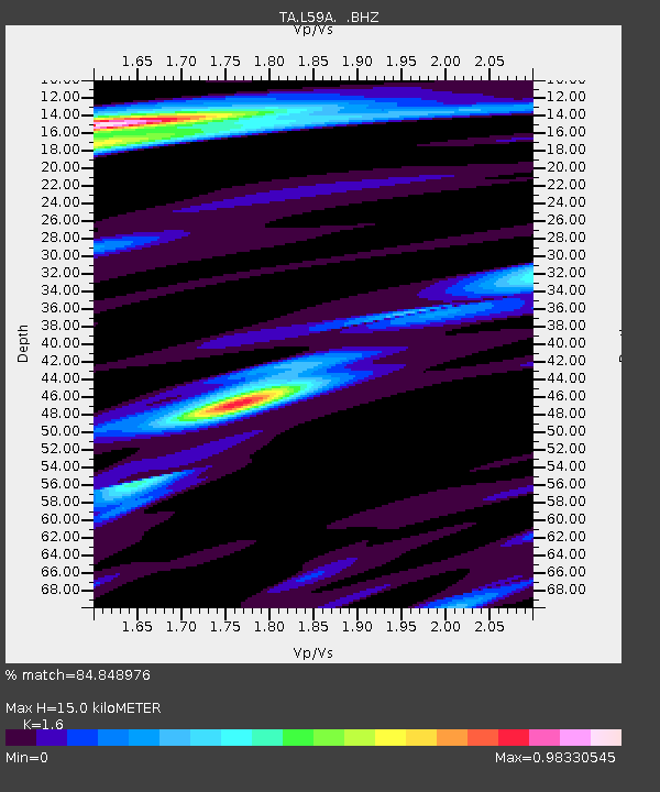
L59A Walton, NY, USA - Earthquake Result Viewer

Earthquake location: Andreanof Islands, Aleutian Is.
Earthquake latitude/longitude: 51.6/-174.7
Earthquake time(UTC): 2013/09/15 (258) 16:21:37 GMT
Earthquake Depth: 24 km
Earthquake Magnitude: 6.1 MWW, 5.7 MI, 5.7 ML, 6.0 MWB, 6.1 MWC, 6.1 MWW
Earthquake Catalog/Contributor: NEIC PDE/NEIC COMCAT
Network: TA USArray Transportable Network (new EarthScope stations)
Station: L59A Walton, NY, USA
Lat/Lon: 42.19 N/75.04 W
Elevation: 677 m
Distance: 63.6 deg
Az: 54.886 deg
Baz: 316.614 deg
Ray Param: 0.059452094
Estimated Moho Depth: 15.0 km
Estimated Crust Vp/Vs: 1.60
Assumed Crust Vp: 6.419 km/s
Estimated Crust Vs: 4.012 km/s
Estimated Crust Poisson's Ratio: 0.18
Radial Match: 84.848976 %
Radial Bump: 400
Transverse Match: 77.42838 %
Transverse Bump: 400
SOD ConfigId: 626651
Insert Time: 2014-04-18 17:27:31.397 +0000
GWidth: 2.5
Max Bumps: 400
Tol: 0.001

Signal To Noise

ChannelStoNSTALTA
TA:L59A: :BHZ:20130915T16:31:34.749976Z11.1013282.2599013E-62.0357035E-7
TA:L59A: :BHN:20130915T16:31:34.749976Z4.5835966.198002E-71.3522136E-7
TA:L59A: :BHE:20130915T16:31:34.749976Z6.5217515.1393584E-77.880336E-8
Arrivals
Ps1.5 SECOND
PpPs5.8 SECOND
PsPs/PpSs7.3 SECOND