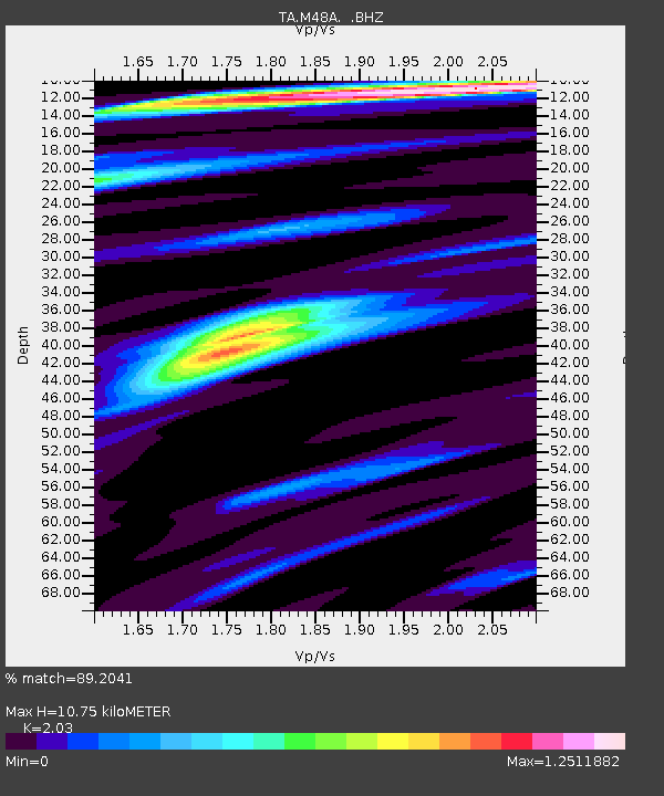
M48A Edgerton, OH, USA - Earthquake Result Viewer
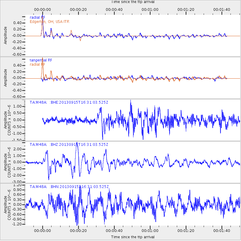
Earthquake location: Andreanof Islands, Aleutian Is.
Earthquake latitude/longitude: 51.6/-174.7
Earthquake time(UTC): 2013/09/15 (258) 16:21:37 GMT
Earthquake Depth: 24 km
Earthquake Magnitude: 6.1 MWW, 5.7 MI, 5.7 ML, 6.0 MWB, 6.1 MWC, 6.1 MWW
Earthquake Catalog/Contributor: NEIC PDE/NEIC COMCAT
Network: TA USArray Transportable Network (new EarthScope stations)
Station: M48A Edgerton, OH, USA
Lat/Lon: 41.48 N/84.72 W
Elevation: 258 m
Distance: 59.0 deg
Az: 61.273 deg
Baz: 313.251 deg
Ray Param: 0.062471773
Estimated Moho Depth: 10.75 km
Estimated Crust Vp/Vs: 2.03
Assumed Crust Vp: 6.498 km/s
Estimated Crust Vs: 3.201 km/s
Estimated Crust Poisson's Ratio: 0.34
Radial Match: 89.2041 %
Radial Bump: 400
Transverse Match: 79.254715 %
Transverse Bump: 400
SOD ConfigId: 626651
Insert Time: 2014-04-18 17:28:08.107 +0000
GWidth: 2.5
Max Bumps: 400
Tol: 0.001

Signal To Noise

ChannelStoNSTALTA
TA:M48A: :BHZ:20130915T16:31:03.525Z7.4940971.1941574E-61.593464E-7
TA:M48A: :BHN:20130915T16:31:03.525Z2.10722733.6886735E-71.7504867E-7
TA:M48A: :BHE:20130915T16:31:03.525Z4.6581615.665548E-71.2162627E-7
Arrivals
Ps1.8 SECOND
PpPs4.8 SECOND
PsPs/PpSs6.6 SECOND