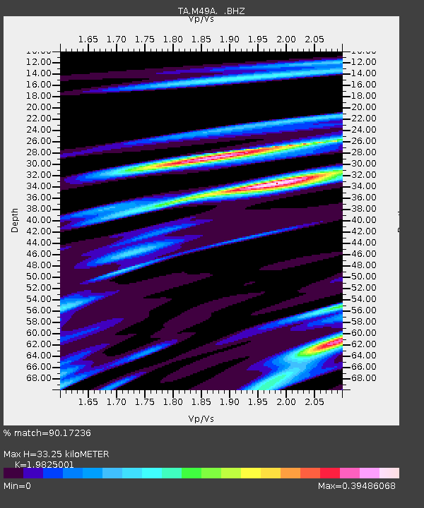
M49A Liberty Center, OH, USA - Earthquake Result Viewer
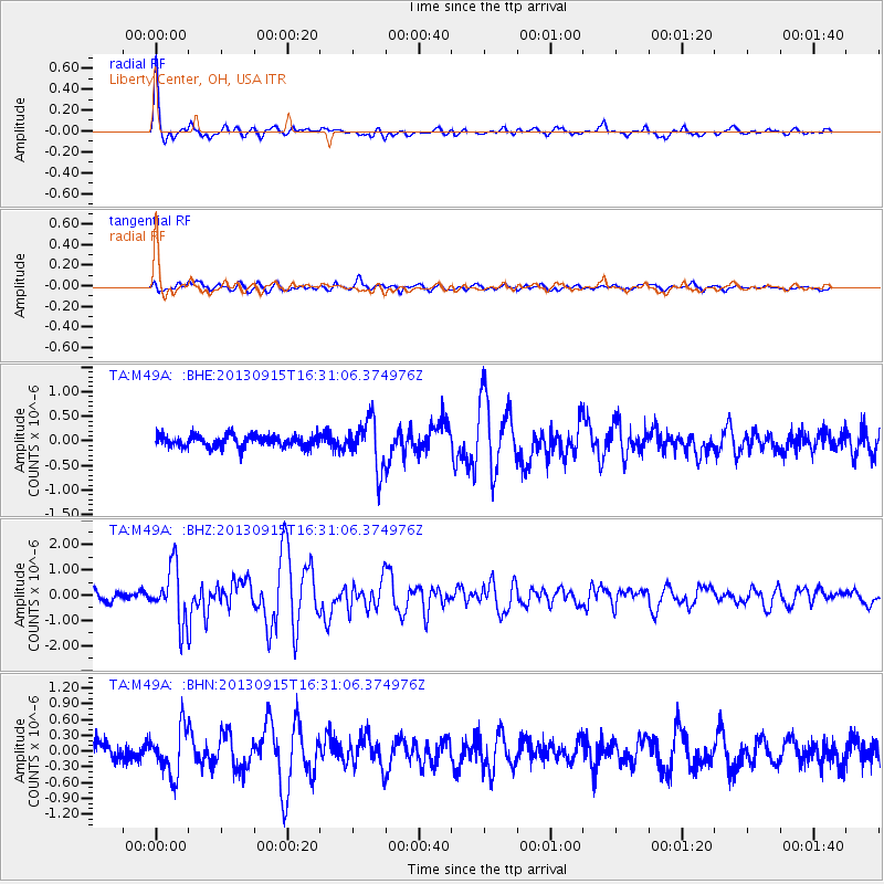
Earthquake location: Andreanof Islands, Aleutian Is.
Earthquake latitude/longitude: 51.6/-174.7
Earthquake time(UTC): 2013/09/15 (258) 16:21:37 GMT
Earthquake Depth: 24 km
Earthquake Magnitude: 6.1 MWW, 5.7 MI, 5.7 ML, 6.0 MWB, 6.1 MWC, 6.1 MWW
Earthquake Catalog/Contributor: NEIC PDE/NEIC COMCAT
Network: TA USArray Transportable Network (new EarthScope stations)
Station: M49A Liberty Center, OH, USA
Lat/Lon: 41.47 N/83.98 W
Elevation: 203 m
Distance: 59.4 deg
Az: 60.835 deg
Baz: 313.517 deg
Ray Param: 0.06219936
Estimated Moho Depth: 33.25 km
Estimated Crust Vp/Vs: 1.98
Assumed Crust Vp: 6.498 km/s
Estimated Crust Vs: 3.277 km/s
Estimated Crust Poisson's Ratio: 0.33
Radial Match: 90.17236 %
Radial Bump: 371
Transverse Match: 79.07595 %
Transverse Bump: 400
SOD ConfigId: 626651
Insert Time: 2014-04-18 17:28:14.351 +0000
GWidth: 2.5
Max Bumps: 400
Tol: 0.001

Signal To Noise

ChannelStoNSTALTA
TA:M49A: :BHZ:20130915T16:31:06.374976Z6.8496321.0853475E-61.5845342E-7
TA:M49A: :BHN:20130915T16:31:06.374976Z2.7037354.472433E-71.6541685E-7
TA:M49A: :BHE:20130915T16:31:06.374976Z4.09181174.9004063E-71.1976128E-7
Arrivals
Ps5.3 SECOND
PpPs15 SECOND
PsPs/PpSs20 SECOND