MDND Maddock, ND, USA - Earthquake Result Viewer
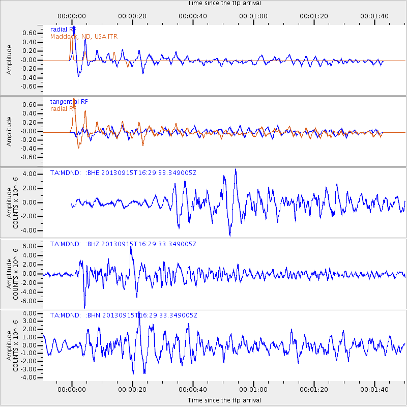
Earthquake location: Andreanof Islands, Aleutian Is.
Earthquake latitude/longitude: 51.6/-174.7
Earthquake time(UTC): 2013/09/15 (258) 16:21:37 GMT
Earthquake Depth: 24 km
Earthquake Magnitude: 6.1 MWW, 5.7 MI, 5.7 ML, 6.0 MWB, 6.1 MWC, 6.1 MWW
Earthquake Catalog/Contributor: NEIC PDE/NEIC COMCAT
Network: TA USArray Transportable Network (new EarthScope stations)
Station: MDND Maddock, ND, USA
Lat/Lon: 47.85 N/99.60 W
Elevation: 479 m
Distance: 46.7 deg
Az: 63.396 deg
Baz: 304.067 deg
Ray Param: 0.070426896
Estimated Moho Depth: 12.25 km
Estimated Crust Vp/Vs: 1.60
Assumed Crust Vp: 6.53 km/s
Estimated Crust Vs: 4.082 km/s
Estimated Crust Poisson's Ratio: 0.18
Radial Match: 90.75908 %
Radial Bump: 396
Transverse Match: 68.474174 %
Transverse Bump: 400
SOD ConfigId: 626651
Insert Time: 2014-04-18 17:29:04.947 +0000
GWidth: 2.5
Max Bumps: 400
Tol: 0.001

Signal To Noise

ChannelStoNSTALTA
TA:MDND: :BHZ:20130915T16:29:33.349005Z9.7835282.3128782E-62.3640534E-7
TA:MDND: :BHN:20130915T16:29:33.349005Z0.58031354.3787884E-77.5455574E-7
TA:MDND: :BHE:20130915T16:29:33.349005Z3.47129251.0989115E-63.165713E-7
Arrivals
Ps1.2 SECOND
PpPs4.5 SECOND
PsPs/PpSs5.7 SECOND