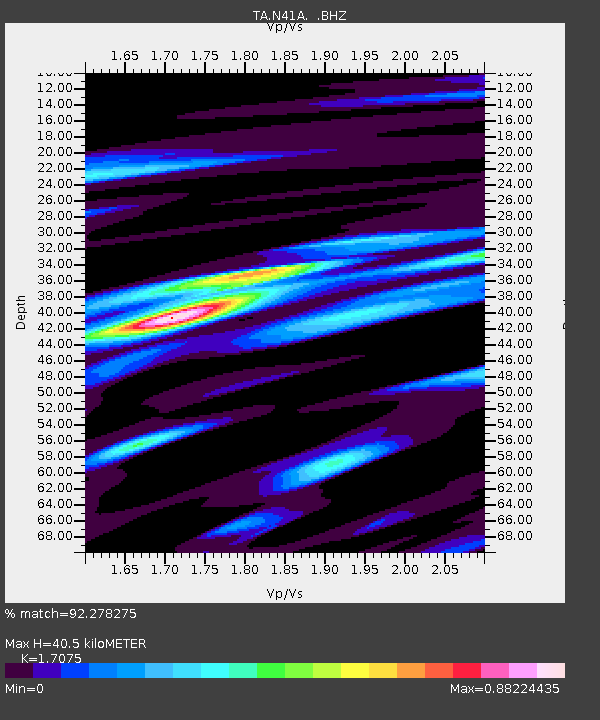
N41A Harden Midland Farm, Stronghurst, IL, USA - Earthquake Result Viewer
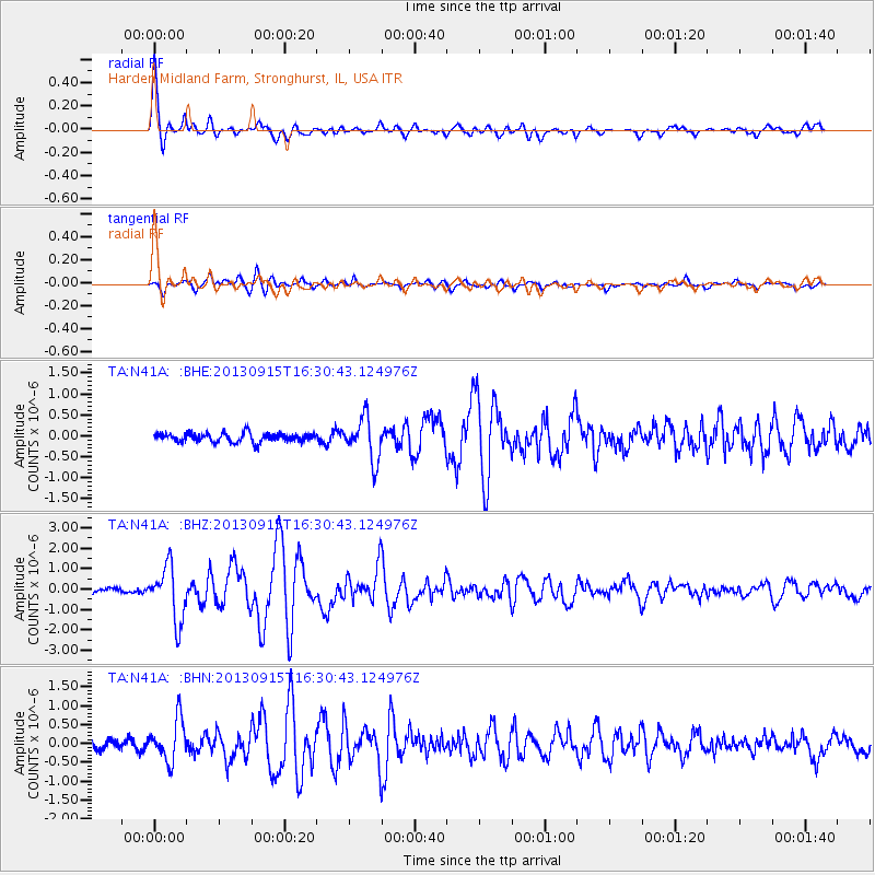
Earthquake location: Andreanof Islands, Aleutian Is.
Earthquake latitude/longitude: 51.6/-174.7
Earthquake time(UTC): 2013/09/15 (258) 16:21:37 GMT
Earthquake Depth: 24 km
Earthquake Magnitude: 6.1 MWW, 5.7 MI, 5.7 ML, 6.0 MWB, 6.1 MWC, 6.1 MWW
Earthquake Catalog/Contributor: NEIC PDE/NEIC COMCAT
Network: TA USArray Transportable Network (new EarthScope stations)
Station: N41A Harden Midland Farm, Stronghurst, IL, USA
Lat/Lon: 40.71 N/90.86 W
Elevation: 226 m
Distance: 56.1 deg
Az: 65.66 deg
Baz: 311.588 deg
Ray Param: 0.06435636
Estimated Moho Depth: 40.5 km
Estimated Crust Vp/Vs: 1.71
Assumed Crust Vp: 6.498 km/s
Estimated Crust Vs: 3.805 km/s
Estimated Crust Poisson's Ratio: 0.24
Radial Match: 92.278275 %
Radial Bump: 399
Transverse Match: 85.4815 %
Transverse Bump: 400
SOD ConfigId: 626651
Insert Time: 2014-04-18 17:29:13.712 +0000
GWidth: 2.5
Max Bumps: 400
Tol: 0.001

Signal To Noise

ChannelStoNSTALTA
TA:N41A: :BHZ:20130915T16:30:43.124976Z8.1902121.3324553E-61.6268874E-7
TA:N41A: :BHN:20130915T16:30:43.124976Z3.56863145.4099183E-71.5159644E-7
TA:N41A: :BHE:20130915T16:30:43.124976Z4.89266255.1214363E-71.0467585E-7
Arrivals
Ps4.7 SECOND
PpPs16 SECOND
PsPs/PpSs21 SECOND