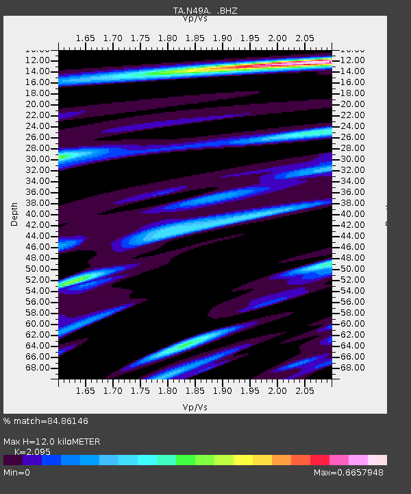
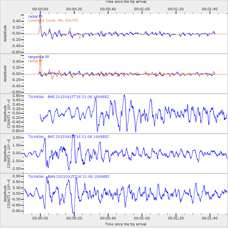
N49A Columbus Grove, OH, USA - Earthquake Result Viewer

Earthquake location: Andreanof Islands, Aleutian Is.
Earthquake latitude/longitude: 51.6/-174.7
Earthquake time(UTC): 2013/09/15 (258) 16:21:37 GMT
Earthquake Depth: 24 km
Earthquake Magnitude: 6.1 MWW, 5.7 MI, 5.7 ML, 6.0 MWB, 6.1 MWC, 6.1 MWW
Earthquake Catalog/Contributor: NEIC PDE/NEIC COMCAT
Network: TA USArray Transportable Network (new EarthScope stations)
Station: N49A Columbus Grove, OH, USA
Lat/Lon: 40.92 N/84.18 W
Elevation: 225 m
Distance: 59.6 deg
Az: 61.424 deg
Baz: 313.68 deg
Ray Param: 0.062023252
Estimated Moho Depth: 12.0 km
Estimated Crust Vp/Vs: 2.10
Assumed Crust Vp: 6.498 km/s
Estimated Crust Vs: 3.101 km/s
Estimated Crust Poisson's Ratio: 0.35
Radial Match: 84.86146 %
Radial Bump: 400
Transverse Match: 55.212864 %
Transverse Bump: 400
SOD ConfigId: 626651
Insert Time: 2014-04-18 17:29:20.204 +0000
GWidth: 2.5
Max Bumps: 400
Tol: 0.001

Signal To Noise

ChannelStoNSTALTA
TA:N49A: :BHZ:20130915T16:31:08.199988Z5.4593641.0752445E-61.9695416E-7
TA:N49A: :BHN:20130915T16:31:08.199988Z2.86257464.6758097E-71.633428E-7
TA:N49A: :BHE:20130915T16:31:08.199988Z2.51305684.3984653E-71.7502452E-7
Arrivals
Ps2.1 SECOND
PpPs5.5 SECOND
PsPs/PpSs7.6 SECOND