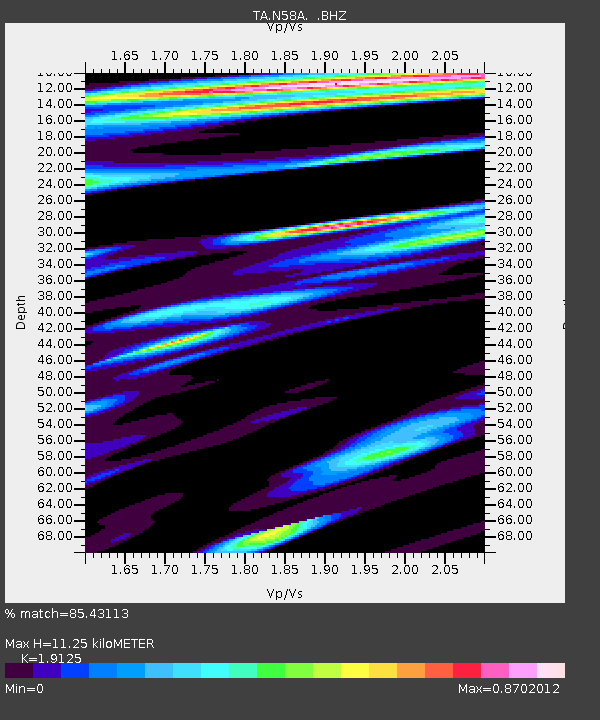
N58A Sunbury, PA, USA - Earthquake Result Viewer

Earthquake location: Andreanof Islands, Aleutian Is.
Earthquake latitude/longitude: 51.6/-174.7
Earthquake time(UTC): 2013/09/15 (258) 16:21:37 GMT
Earthquake Depth: 24 km
Earthquake Magnitude: 6.1 MWW, 5.7 MI, 5.7 ML, 6.0 MWB, 6.1 MWC, 6.1 MWW
Earthquake Catalog/Contributor: NEIC PDE/NEIC COMCAT
Network: TA USArray Transportable Network (new EarthScope stations)
Station: N58A Sunbury, PA, USA
Lat/Lon: 40.84 N/76.72 W
Elevation: 200 m
Distance: 63.7 deg
Az: 56.94 deg
Baz: 316.421 deg
Ray Param: 0.05937731
Estimated Moho Depth: 11.25 km
Estimated Crust Vp/Vs: 1.91
Assumed Crust Vp: 6.121 km/s
Estimated Crust Vs: 3.2 km/s
Estimated Crust Poisson's Ratio: 0.31
Radial Match: 85.43113 %
Radial Bump: 400
Transverse Match: 84.98729 %
Transverse Bump: 400
SOD ConfigId: 626651
Insert Time: 2014-04-18 17:29:45.740 +0000
GWidth: 2.5
Max Bumps: 400
Tol: 0.001

Signal To Noise

ChannelStoNSTALTA
TA:N58A: :BHZ:20130915T16:31:35.499976Z7.52454331.6870044E-62.2420024E-7
TA:N58A: :BHN:20130915T16:31:35.499976Z2.80934643.781855E-71.346169E-7
TA:N58A: :BHE:20130915T16:31:35.499976Z3.61903644.6253467E-71.2780603E-7
Arrivals
Ps1.7 SECOND
PpPs5.2 SECOND
PsPs/PpSs6.9 SECOND