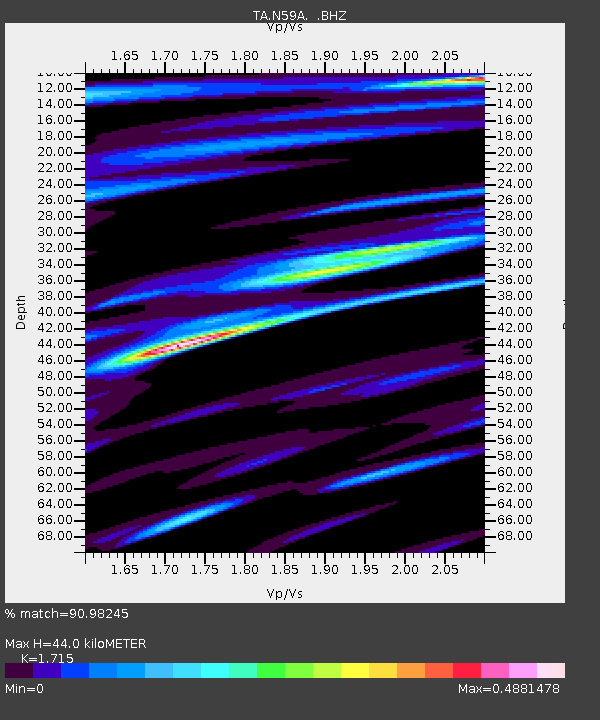
N59A State Game Land 141, Hazleton, PA, USA - Earthquake Result Viewer
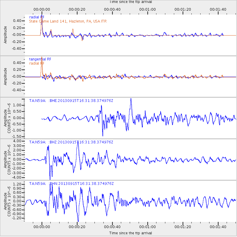
Earthquake location: Andreanof Islands, Aleutian Is.
Earthquake latitude/longitude: 51.6/-174.7
Earthquake time(UTC): 2013/09/15 (258) 16:21:37 GMT
Earthquake Depth: 24 km
Earthquake Magnitude: 6.1 MWW, 5.7 MI, 5.7 ML, 6.0 MWB, 6.1 MWC, 6.1 MWW
Earthquake Catalog/Contributor: NEIC PDE/NEIC COMCAT
Network: TA USArray Transportable Network (new EarthScope stations)
Station: N59A State Game Land 141, Hazleton, PA, USA
Lat/Lon: 40.92 N/75.77 W
Elevation: 508 m
Distance: 64.1 deg
Az: 56.301 deg
Baz: 316.757 deg
Ray Param: 0.059087798
Estimated Moho Depth: 44.0 km
Estimated Crust Vp/Vs: 1.72
Assumed Crust Vp: 6.283 km/s
Estimated Crust Vs: 3.664 km/s
Estimated Crust Poisson's Ratio: 0.24
Radial Match: 90.98245 %
Radial Bump: 400
Transverse Match: 86.50088 %
Transverse Bump: 400
SOD ConfigId: 626651
Insert Time: 2014-04-18 17:29:49.415 +0000
GWidth: 2.5
Max Bumps: 400
Tol: 0.001

Signal To Noise

ChannelStoNSTALTA
TA:N59A: :BHZ:20130915T16:31:38.374976Z11.0894171.6052912E-61.4475883E-7
TA:N59A: :BHN:20130915T16:31:38.374976Z4.0368145.018066E-71.2430758E-7
TA:N59A: :BHE:20130915T16:31:38.374976Z4.7466774.897975E-71.0318746E-7
Arrivals
Ps5.2 SECOND
PpPs18 SECOND
PsPs/PpSs23 SECOND