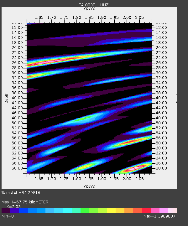
O03E Paynes Creek, CA, USA - Earthquake Result Viewer
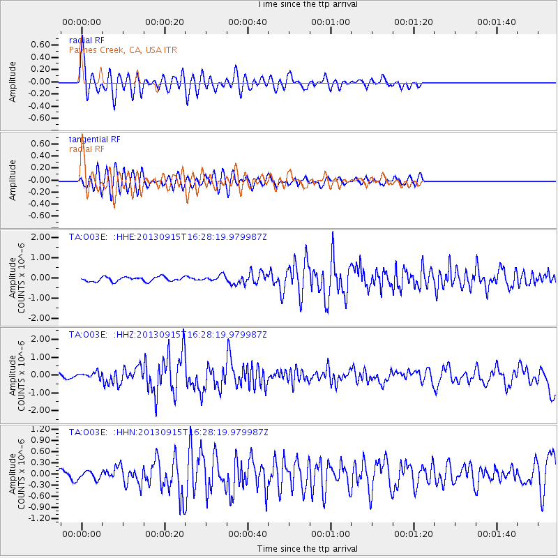
Earthquake location: Andreanof Islands, Aleutian Is.
Earthquake latitude/longitude: 51.6/-174.7
Earthquake time(UTC): 2013/09/15 (258) 16:21:37 GMT
Earthquake Depth: 24 km
Earthquake Magnitude: 6.1 MWW, 5.7 MI, 5.7 ML, 6.0 MWB, 6.1 MWC, 6.1 MWW
Earthquake Catalog/Contributor: NEIC PDE/NEIC COMCAT
Network: TA USArray Transportable Network (new EarthScope stations)
Station: O03E Paynes Creek, CA, USA
Lat/Lon: 40.29 N/121.80 W
Elevation: 967 m
Distance: 37.7 deg
Az: 86.099 deg
Baz: 305.511 deg
Ray Param: 0.075949684
Estimated Moho Depth: 67.75 km
Estimated Crust Vp/Vs: 2.03
Assumed Crust Vp: 6.566 km/s
Estimated Crust Vs: 3.235 km/s
Estimated Crust Poisson's Ratio: 0.34
Radial Match: 84.20816 %
Radial Bump: 400
Transverse Match: 70.40587 %
Transverse Bump: 400
SOD ConfigId: 626651
Insert Time: 2014-04-18 17:30:01.901 +0000
GWidth: 2.5
Max Bumps: 400
Tol: 0.001

Signal To Noise

ChannelStoNSTALTA
TA:O03E: :HHZ:20130915T16:28:19.979987Z1.79669171.741329E-79.6918626E-8
TA:O03E: :HHN:20130915T16:28:19.979987Z0.980791451.0847141E-71.1059579E-7
TA:O03E: :HHE:20130915T16:28:19.979987Z1.37571641.5252907E-71.1087246E-7
Arrivals
Ps11 SECOND
PpPs29 SECOND
PsPs/PpSs41 SECOND