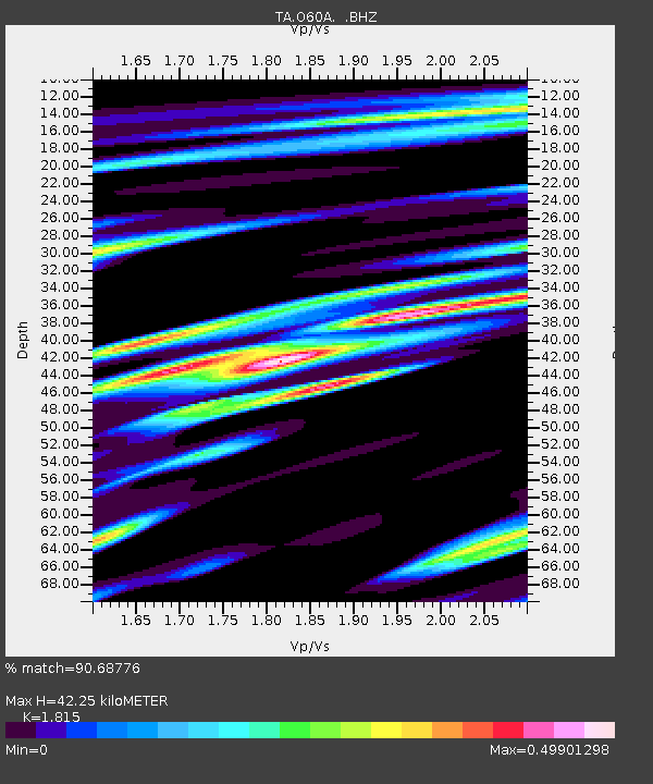
O60A Telford, PA, USA - Earthquake Result Viewer

Earthquake location: Andreanof Islands, Aleutian Is.
Earthquake latitude/longitude: 51.6/-174.7
Earthquake time(UTC): 2013/09/15 (258) 16:21:37 GMT
Earthquake Depth: 24 km
Earthquake Magnitude: 6.1 MWW, 5.7 MI, 5.7 ML, 6.0 MWB, 6.1 MWC, 6.1 MWW
Earthquake Catalog/Contributor: NEIC PDE/NEIC COMCAT
Network: TA USArray Transportable Network (new EarthScope stations)
Station: O60A Telford, PA, USA
Lat/Lon: 40.32 N/75.40 W
Elevation: 70 m
Distance: 64.8 deg
Az: 56.529 deg
Baz: 317.092 deg
Ray Param: 0.058684878
Estimated Moho Depth: 42.25 km
Estimated Crust Vp/Vs: 1.82
Assumed Crust Vp: 6.283 km/s
Estimated Crust Vs: 3.462 km/s
Estimated Crust Poisson's Ratio: 0.28
Radial Match: 90.68776 %
Radial Bump: 400
Transverse Match: 75.57919 %
Transverse Bump: 400
SOD ConfigId: 626651
Insert Time: 2014-04-18 17:30:36.268 +0000
GWidth: 2.5
Max Bumps: 400
Tol: 0.001

Signal To Noise

ChannelStoNSTALTA
TA:O60A: :BHZ:20130915T16:31:42.475012Z10.7101471.609009E-61.5023221E-7
TA:O60A: :BHN:20130915T16:31:42.475012Z4.2656964.802461E-71.12583294E-7
TA:O60A: :BHE:20130915T16:31:42.475012Z3.94973474.8039306E-71.2162667E-7
Arrivals
Ps5.7 SECOND
PpPs18 SECOND
PsPs/PpSs24 SECOND