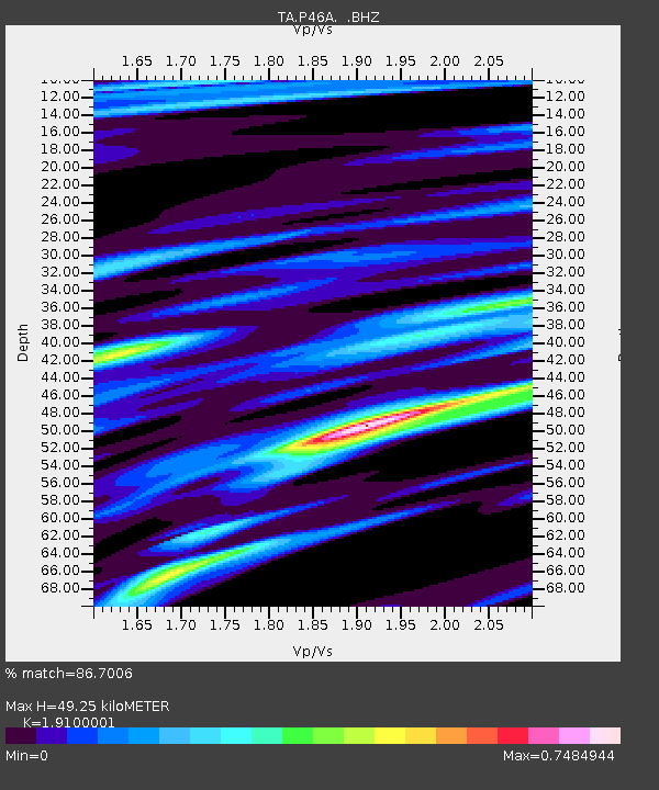
P46A Rosedale, IN, USA - Earthquake Result Viewer
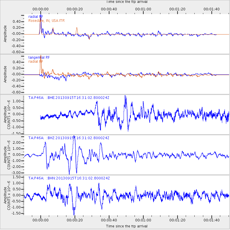
Earthquake location: Andreanof Islands, Aleutian Is.
Earthquake latitude/longitude: 51.6/-174.7
Earthquake time(UTC): 2013/09/15 (258) 16:21:37 GMT
Earthquake Depth: 24 km
Earthquake Magnitude: 6.1 MWW, 5.7 MI, 5.7 ML, 6.0 MWB, 6.1 MWC, 6.1 MWW
Earthquake Catalog/Contributor: NEIC PDE/NEIC COMCAT
Network: TA USArray Transportable Network (new EarthScope stations)
Station: P46A Rosedale, IN, USA
Lat/Lon: 39.62 N/87.21 W
Elevation: 194 m
Distance: 58.9 deg
Az: 64.377 deg
Baz: 313.242 deg
Ray Param: 0.06253981
Estimated Moho Depth: 49.25 km
Estimated Crust Vp/Vs: 1.91
Assumed Crust Vp: 6.444 km/s
Estimated Crust Vs: 3.374 km/s
Estimated Crust Poisson's Ratio: 0.31
Radial Match: 86.7006 %
Radial Bump: 400
Transverse Match: 69.571526 %
Transverse Bump: 400
SOD ConfigId: 626651
Insert Time: 2014-04-18 17:30:41.554 +0000
GWidth: 2.5
Max Bumps: 400
Tol: 0.001

Signal To Noise

ChannelStoNSTALTA
TA:P46A: :BHZ:20130915T16:31:02.800024Z7.43399951.2456479E-61.6756094E-7
TA:P46A: :BHN:20130915T16:31:02.800024Z2.27201343.3668624E-71.4818849E-7
TA:P46A: :BHE:20130915T16:31:02.800024Z3.48780875.3090093E-71.5221619E-7
Arrivals
Ps7.3 SECOND
PpPs21 SECOND
PsPs/PpSs29 SECOND