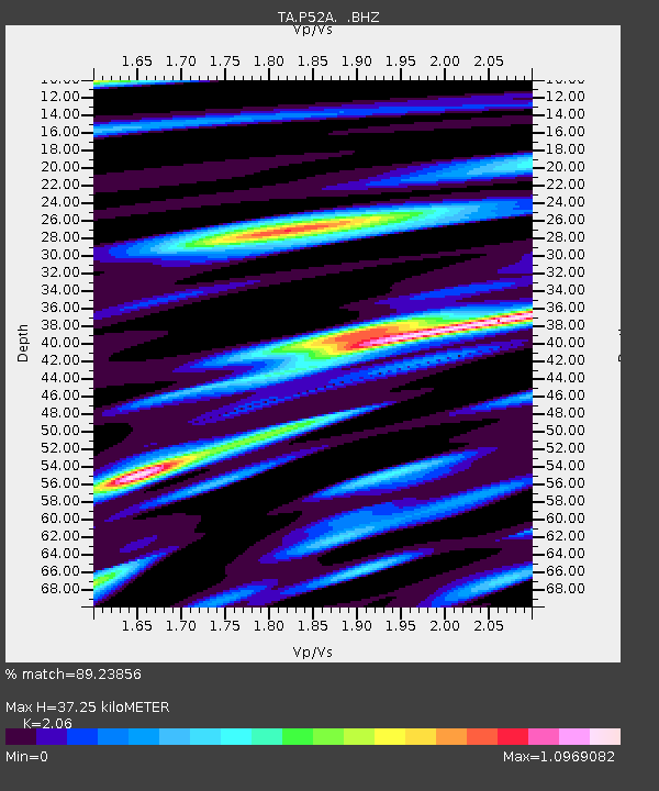
P52A Corning, OH, USA - Earthquake Result Viewer

Earthquake location: Andreanof Islands, Aleutian Is.
Earthquake latitude/longitude: 51.6/-174.7
Earthquake time(UTC): 2013/09/15 (258) 16:21:37 GMT
Earthquake Depth: 24 km
Earthquake Magnitude: 6.1 MWW, 5.7 MI, 5.7 ML, 6.0 MWB, 6.1 MWC, 6.1 MWW
Earthquake Catalog/Contributor: NEIC PDE/NEIC COMCAT
Network: TA USArray Transportable Network (new EarthScope stations)
Station: P52A Corning, OH, USA
Lat/Lon: 39.63 N/82.13 W
Elevation: 293 m
Distance: 61.7 deg
Az: 61.225 deg
Baz: 314.902 deg
Ray Param: 0.06070168
Estimated Moho Depth: 37.25 km
Estimated Crust Vp/Vs: 2.06
Assumed Crust Vp: 6.232 km/s
Estimated Crust Vs: 3.025 km/s
Estimated Crust Poisson's Ratio: 0.35
Radial Match: 89.23856 %
Radial Bump: 400
Transverse Match: 65.92889 %
Transverse Bump: 400
SOD ConfigId: 626651
Insert Time: 2014-04-18 17:30:56.813 +0000
GWidth: 2.5
Max Bumps: 400
Tol: 0.001

Signal To Noise

ChannelStoNSTALTA
TA:P52A: :BHZ:20130915T16:31:21.949988Z12.172011.1031356E-69.062887E-8
TA:P52A: :BHN:20130915T16:31:21.949988Z5.92144254.9701157E-78.3934204E-8
TA:P52A: :BHE:20130915T16:31:21.949988Z1.84483893.0537583E-71.6552983E-7
Arrivals
Ps6.6 SECOND
PpPs18 SECOND
PsPs/PpSs24 SECOND