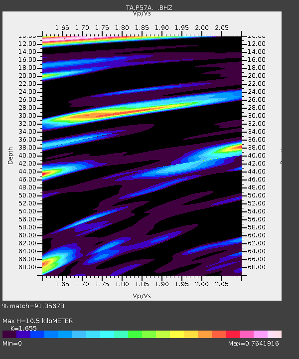
P57A Homestead Farm, Martinsburg, WV, USA - Earthquake Result Viewer
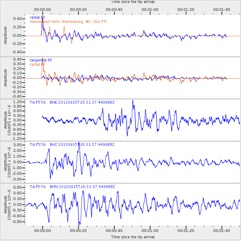
Earthquake location: Andreanof Islands, Aleutian Is.
Earthquake latitude/longitude: 51.6/-174.7
Earthquake time(UTC): 2013/09/15 (258) 16:21:37 GMT
Earthquake Depth: 24 km
Earthquake Magnitude: 6.1 MWW, 5.7 MI, 5.7 ML, 6.0 MWB, 6.1 MWC, 6.1 MWW
Earthquake Catalog/Contributor: NEIC PDE/NEIC COMCAT
Network: TA USArray Transportable Network (new EarthScope stations)
Station: P57A Homestead Farm, Martinsburg, WV, USA
Lat/Lon: 39.48 N/78.01 W
Elevation: 191 m
Distance: 64.0 deg
Az: 58.783 deg
Baz: 316.4 deg
Ray Param: 0.05918117
Estimated Moho Depth: 10.5 km
Estimated Crust Vp/Vs: 1.65
Assumed Crust Vp: 6.159 km/s
Estimated Crust Vs: 3.721 km/s
Estimated Crust Poisson's Ratio: 0.21
Radial Match: 91.35678 %
Radial Bump: 400
Transverse Match: 73.85685 %
Transverse Bump: 400
SOD ConfigId: 626651
Insert Time: 2014-04-18 17:31:09.685 +0000
GWidth: 2.5
Max Bumps: 400
Tol: 0.001

Signal To Noise

ChannelStoNSTALTA
TA:P57A: :BHZ:20130915T16:31:37.449988Z10.3594521.2332641E-61.1904723E-7
TA:P57A: :BHN:20130915T16:31:37.449988Z3.77042533.3703503E-78.9389125E-8
TA:P57A: :BHE:20130915T16:31:37.449988Z2.81565643.0699883E-71.0903277E-7
Arrivals
Ps1.2 SECOND
PpPs4.3 SECOND
PsPs/PpSs5.5 SECOND