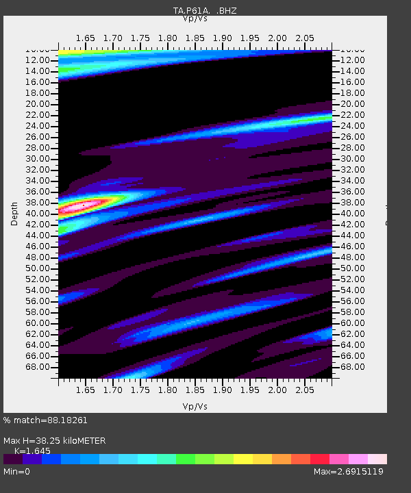
P61A Hammonton, NJ, USA - Earthquake Result Viewer
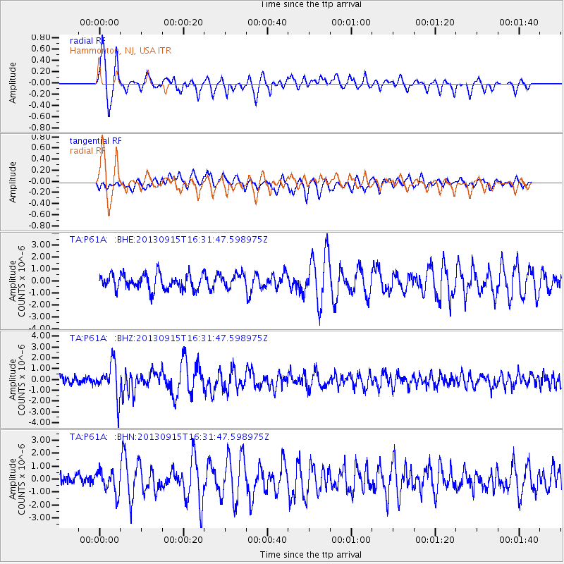
Earthquake location: Andreanof Islands, Aleutian Is.
Earthquake latitude/longitude: 51.6/-174.7
Earthquake time(UTC): 2013/09/15 (258) 16:21:37 GMT
Earthquake Depth: 24 km
Earthquake Magnitude: 6.1 MWW, 5.7 MI, 5.7 ML, 6.0 MWB, 6.1 MWC, 6.1 MWW
Earthquake Catalog/Contributor: NEIC PDE/NEIC COMCAT
Network: TA USArray Transportable Network (new EarthScope stations)
Station: P61A Hammonton, NJ, USA
Lat/Lon: 39.67 N/74.79 W
Elevation: 22 m
Distance: 65.6 deg
Az: 56.629 deg
Baz: 317.526 deg
Ray Param: 0.058165323
Estimated Moho Depth: 38.25 km
Estimated Crust Vp/Vs: 1.64
Assumed Crust Vp: 6.287 km/s
Estimated Crust Vs: 3.822 km/s
Estimated Crust Poisson's Ratio: 0.21
Radial Match: 88.18261 %
Radial Bump: 364
Transverse Match: 67.501396 %
Transverse Bump: 400
SOD ConfigId: 626651
Insert Time: 2014-04-18 17:31:27.324 +0000
GWidth: 2.5
Max Bumps: 400
Tol: 0.001

Signal To Noise

ChannelStoNSTALTA
TA:P61A: :BHZ:20130915T16:31:47.598975Z5.46711251.5839386E-62.897212E-7
TA:P61A: :BHN:20130915T16:31:47.598975Z1.72618078.7501246E-75.0690664E-7
TA:P61A: :BHE:20130915T16:31:47.598975Z0.94120095.920803E-76.29069E-7
Arrivals
Ps4.1 SECOND
PpPs15 SECOND
PsPs/PpSs20 SECOND