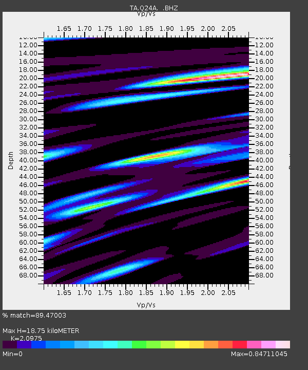
Q24A Divide, CO, USA - Earthquake Result Viewer
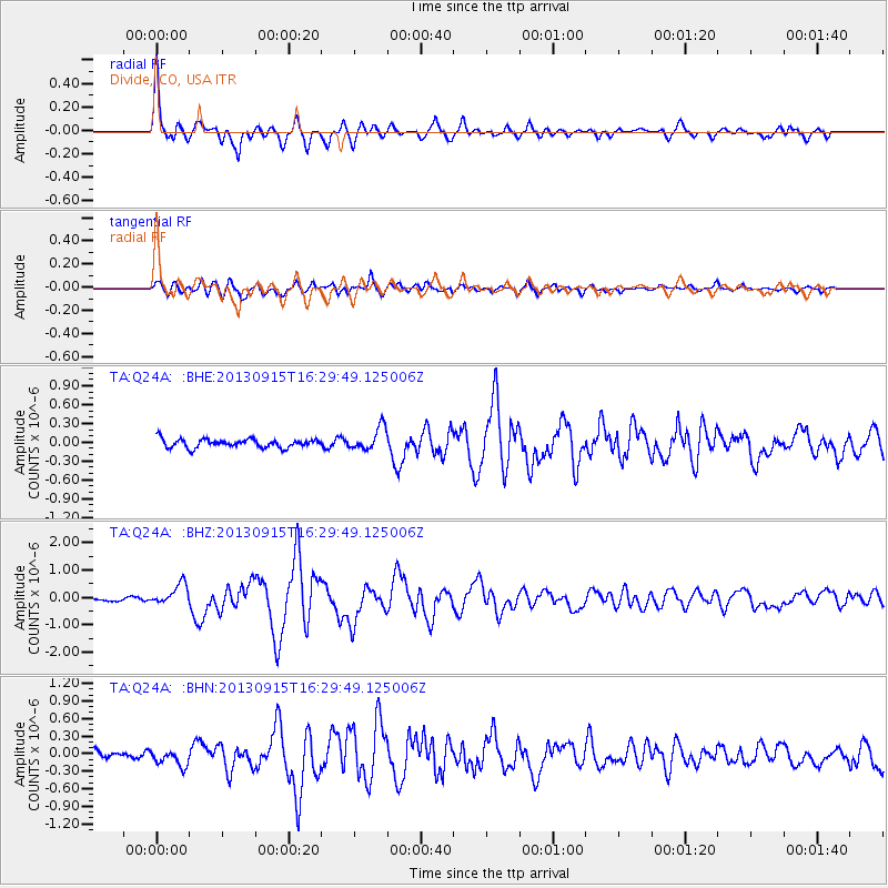
Earthquake location: Andreanof Islands, Aleutian Is.
Earthquake latitude/longitude: 51.6/-174.7
Earthquake time(UTC): 2013/09/15 (258) 16:21:37 GMT
Earthquake Depth: 24 km
Earthquake Magnitude: 6.1 MWW, 5.7 MI, 5.7 ML, 6.0 MWB, 6.1 MWC, 6.1 MWW
Earthquake Catalog/Contributor: NEIC PDE/NEIC COMCAT
Network: TA USArray Transportable Network (new EarthScope stations)
Station: Q24A Divide, CO, USA
Lat/Lon: 38.96 N/105.15 W
Elevation: 2775 m
Distance: 48.8 deg
Az: 76.295 deg
Baz: 308.951 deg
Ray Param: 0.06910812
Estimated Moho Depth: 18.75 km
Estimated Crust Vp/Vs: 2.10
Assumed Crust Vp: 6.159 km/s
Estimated Crust Vs: 2.936 km/s
Estimated Crust Poisson's Ratio: 0.35
Radial Match: 89.47003 %
Radial Bump: 400
Transverse Match: 79.74216 %
Transverse Bump: 400
SOD ConfigId: 626651
Insert Time: 2014-04-18 17:31:30.690 +0000
GWidth: 2.5
Max Bumps: 400
Tol: 0.001

Signal To Noise

ChannelStoNSTALTA
TA:Q24A: :BHZ:20130915T16:29:49.125006Z3.65288453.8741652E-71.060577E-7
TA:Q24A: :BHN:20130915T16:29:49.125006Z2.1711581.38276E-76.368767E-8
TA:Q24A: :BHE:20130915T16:29:49.125006Z2.68220451.8138236E-76.762436E-8
Arrivals
Ps3.5 SECOND
PpPs9.0 SECOND
PsPs/PpSs13 SECOND