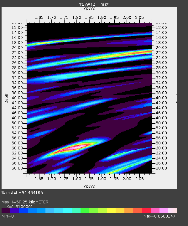
Q51A Peebles, OH, USA - Earthquake Result Viewer
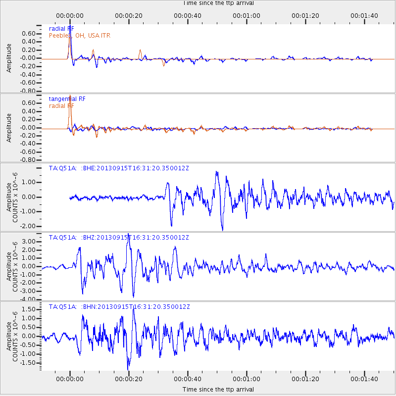
Earthquake location: Andreanof Islands, Aleutian Is.
Earthquake latitude/longitude: 51.6/-174.7
Earthquake time(UTC): 2013/09/15 (258) 16:21:37 GMT
Earthquake Depth: 24 km
Earthquake Magnitude: 6.1 MWW, 5.7 MI, 5.7 ML, 6.0 MWB, 6.1 MWC, 6.1 MWW
Earthquake Catalog/Contributor: NEIC PDE/NEIC COMCAT
Network: TA USArray Transportable Network (new EarthScope stations)
Station: Q51A Peebles, OH, USA
Lat/Lon: 39.03 N/83.35 W
Elevation: 362 m
Distance: 61.4 deg
Az: 62.469 deg
Baz: 314.729 deg
Ray Param: 0.06085346
Estimated Moho Depth: 59.25 km
Estimated Crust Vp/Vs: 1.81
Assumed Crust Vp: 6.232 km/s
Estimated Crust Vs: 3.443 km/s
Estimated Crust Poisson's Ratio: 0.28
Radial Match: 94.464195 %
Radial Bump: 324
Transverse Match: 79.06409 %
Transverse Bump: 400
SOD ConfigId: 626651
Insert Time: 2014-04-18 17:31:47.134 +0000
GWidth: 2.5
Max Bumps: 400
Tol: 0.001

Signal To Noise

ChannelStoNSTALTA
TA:Q51A: :BHZ:20130915T16:31:20.350012Z12.0723571.3566582E-61.1237724E-7
TA:Q51A: :BHN:20130915T16:31:20.350012Z3.46930175.312823E-71.531381E-7
TA:Q51A: :BHE:20130915T16:31:20.350012Z10.1470897.2782456E-77.172743E-8
Arrivals
Ps8.0 SECOND
PpPs26 SECOND
PsPs/PpSs34 SECOND