Q54A Coxs Mills, WV, USA - Earthquake Result Viewer
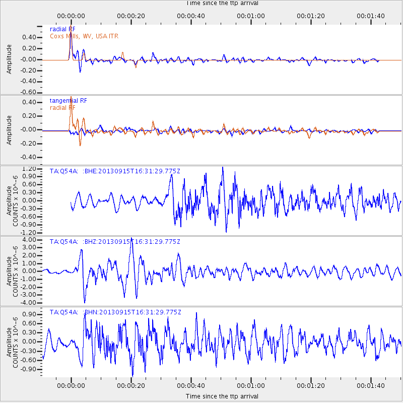
Earthquake location: Andreanof Islands, Aleutian Is.
Earthquake latitude/longitude: 51.6/-174.7
Earthquake time(UTC): 2013/09/15 (258) 16:21:37 GMT
Earthquake Depth: 24 km
Earthquake Magnitude: 6.1 MWW, 5.7 MI, 5.7 ML, 6.0 MWB, 6.1 MWC, 6.1 MWW
Earthquake Catalog/Contributor: NEIC PDE/NEIC COMCAT
Network: TA USArray Transportable Network (new EarthScope stations)
Station: Q54A Coxs Mills, WV, USA
Lat/Lon: 38.98 N/80.83 W
Elevation: 254 m
Distance: 62.8 deg
Az: 60.933 deg
Baz: 315.585 deg
Ray Param: 0.059939448
Estimated Moho Depth: 35.0 km
Estimated Crust Vp/Vs: 1.70
Assumed Crust Vp: 6.207 km/s
Estimated Crust Vs: 3.651 km/s
Estimated Crust Poisson's Ratio: 0.24
Radial Match: 83.759796 %
Radial Bump: 400
Transverse Match: 70.16775 %
Transverse Bump: 400
SOD ConfigId: 626651
Insert Time: 2014-04-18 17:31:51.828 +0000
GWidth: 2.5
Max Bumps: 400
Tol: 0.001

Signal To Noise

ChannelStoNSTALTA
TA:Q54A: :BHZ:20130915T16:31:29.775Z6.8584631.6384492E-62.3889453E-7
TA:Q54A: :BHN:20130915T16:31:29.775Z2.14920744.3628356E-72.0299743E-7
TA:Q54A: :BHE:20130915T16:31:29.775Z2.61794544.811073E-71.8377285E-7
Arrivals
Ps4.1 SECOND
PpPs15 SECOND
PsPs/PpSs19 SECOND