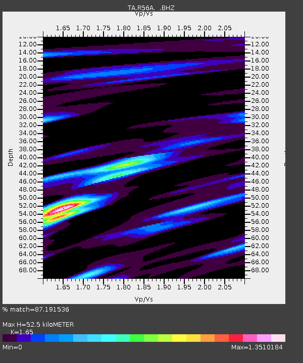
R56A Bull Pasture Mountain, McDowell, VA, USA - Earthquake Result Viewer
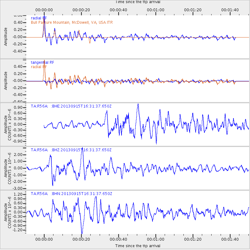
Earthquake location: Andreanof Islands, Aleutian Is.
Earthquake latitude/longitude: 51.6/-174.7
Earthquake time(UTC): 2013/09/15 (258) 16:21:37 GMT
Earthquake Depth: 24 km
Earthquake Magnitude: 6.1 MWW, 5.7 MI, 5.7 ML, 6.0 MWB, 6.1 MWC, 6.1 MWW
Earthquake Catalog/Contributor: NEIC PDE/NEIC COMCAT
Network: TA USArray Transportable Network (new EarthScope stations)
Station: R56A Bull Pasture Mountain, McDowell, VA, USA
Lat/Lon: 38.41 N/79.40 W
Elevation: 902 m
Distance: 64.0 deg
Az: 60.481 deg
Baz: 316.274 deg
Ray Param: 0.059162006
Estimated Moho Depth: 52.5 km
Estimated Crust Vp/Vs: 1.65
Assumed Crust Vp: 6.159 km/s
Estimated Crust Vs: 3.733 km/s
Estimated Crust Poisson's Ratio: 0.21
Radial Match: 87.191536 %
Radial Bump: 400
Transverse Match: 69.75173 %
Transverse Bump: 400
SOD ConfigId: 626651
Insert Time: 2014-04-18 17:32:44.379 +0000
GWidth: 2.5
Max Bumps: 400
Tol: 0.001

Signal To Noise

ChannelStoNSTALTA
TA:R56A: :BHZ:20130915T16:31:37.650Z6.2281241.0731237E-61.7230288E-7
TA:R56A: :BHN:20130915T16:31:37.650Z2.08546663.3167348E-71.5904041E-7
TA:R56A: :BHE:20130915T16:31:37.650Z2.9949283.345145E-71.1169368E-7
Arrivals
Ps5.8 SECOND
PpPs22 SECOND
PsPs/PpSs27 SECOND