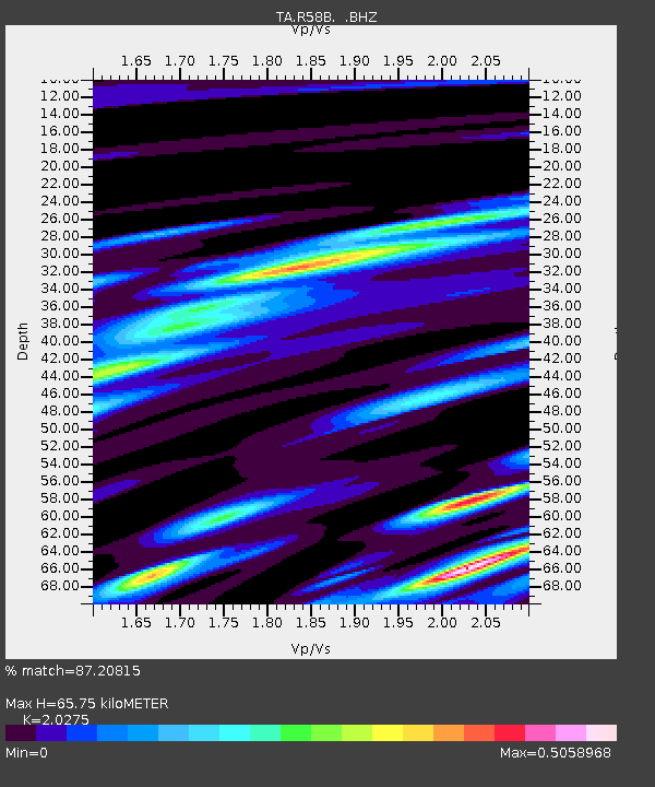
R58B Mineral, VA, USA - Earthquake Result Viewer

Earthquake location: Andreanof Islands, Aleutian Is.
Earthquake latitude/longitude: 51.6/-174.7
Earthquake time(UTC): 2013/09/15 (258) 16:21:37 GMT
Earthquake Depth: 24 km
Earthquake Magnitude: 6.1 MWW, 5.7 MI, 5.7 ML, 6.0 MWB, 6.1 MWC, 6.1 MWW
Earthquake Catalog/Contributor: NEIC PDE/NEIC COMCAT
Network: TA USArray Transportable Network (new EarthScope stations)
Station: R58B Mineral, VA, USA
Lat/Lon: 37.96 N/77.88 W
Elevation: 116 m
Distance: 65.2 deg
Az: 59.851 deg
Baz: 316.943 deg
Ray Param: 0.05841761
Estimated Moho Depth: 65.75 km
Estimated Crust Vp/Vs: 2.03
Assumed Crust Vp: 6.565 km/s
Estimated Crust Vs: 3.238 km/s
Estimated Crust Poisson's Ratio: 0.34
Radial Match: 87.20815 %
Radial Bump: 400
Transverse Match: 72.724045 %
Transverse Bump: 400
SOD ConfigId: 626651
Insert Time: 2014-04-18 17:32:54.781 +0000
GWidth: 2.5
Max Bumps: 400
Tol: 0.001

Signal To Noise

ChannelStoNSTALTA
TA:R58B: :BHZ:20130915T16:31:45.124976Z8.572491.1946662E-61.3936048E-7
TA:R58B: :BHN:20130915T16:31:45.124976Z2.84833863.9562678E-71.3889739E-7
TA:R58B: :BHE:20130915T16:31:45.124976Z3.75548674.2071144E-71.120258E-7
Arrivals
Ps11 SECOND
PpPs29 SECOND
PsPs/PpSs40 SECOND