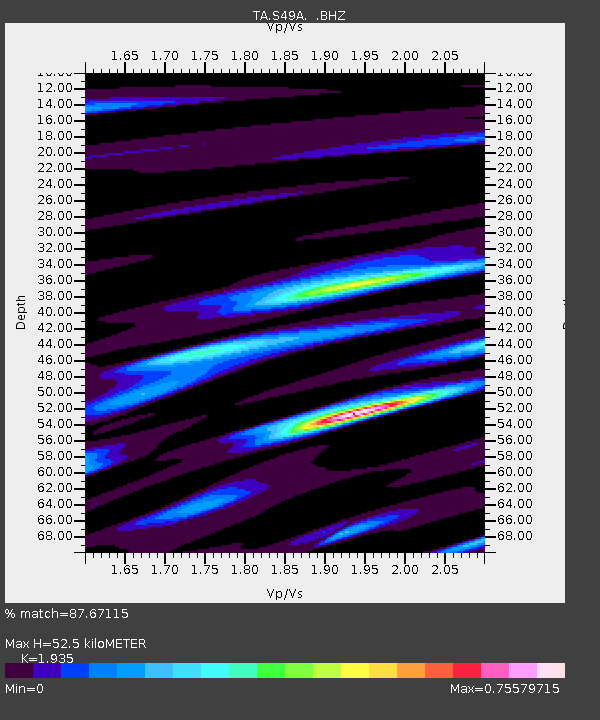
S49A Springfield, KY, USA - Earthquake Result Viewer
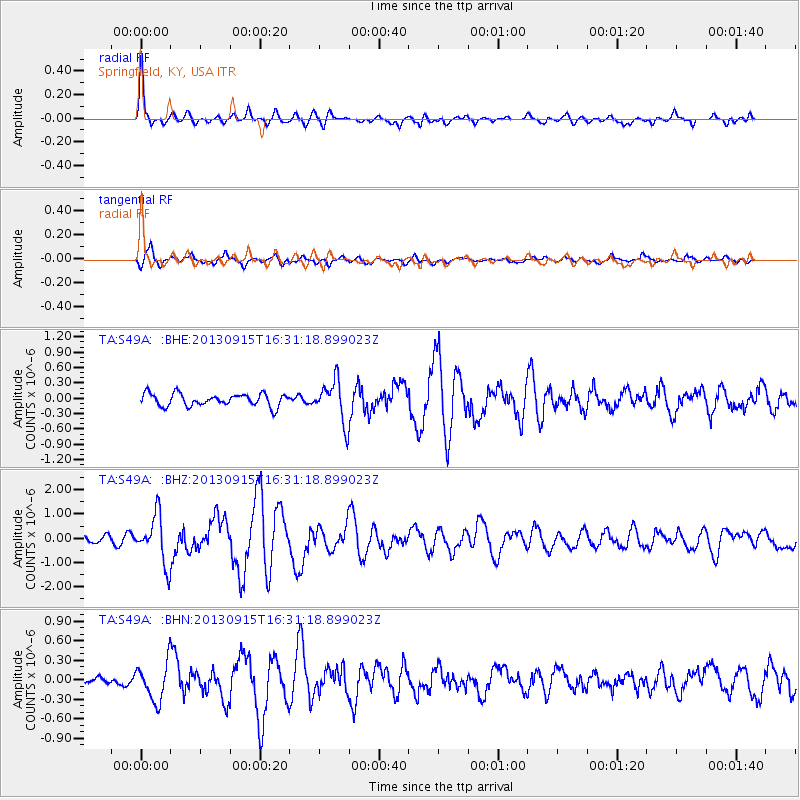
Earthquake location: Andreanof Islands, Aleutian Is.
Earthquake latitude/longitude: 51.6/-174.7
Earthquake time(UTC): 2013/09/15 (258) 16:21:37 GMT
Earthquake Depth: 24 km
Earthquake Magnitude: 6.1 MWW, 5.7 MI, 5.7 ML, 6.0 MWB, 6.1 MWC, 6.1 MWW
Earthquake Catalog/Contributor: NEIC PDE/NEIC COMCAT
Network: TA USArray Transportable Network (new EarthScope stations)
Station: S49A Springfield, KY, USA
Lat/Lon: 37.78 N/85.29 W
Elevation: 230 m
Distance: 61.2 deg
Az: 64.696 deg
Baz: 314.597 deg
Ray Param: 0.060992293
Estimated Moho Depth: 52.5 km
Estimated Crust Vp/Vs: 1.93
Assumed Crust Vp: 6.476 km/s
Estimated Crust Vs: 3.347 km/s
Estimated Crust Poisson's Ratio: 0.32
Radial Match: 87.67115 %
Radial Bump: 400
Transverse Match: 78.199066 %
Transverse Bump: 400
SOD ConfigId: 626651
Insert Time: 2014-04-18 17:33:17.073 +0000
GWidth: 2.5
Max Bumps: 400
Tol: 0.001

Signal To Noise

ChannelStoNSTALTA
TA:S49A: :BHZ:20130915T16:31:18.899023Z8.2104689.909877E-71.2069808E-7
TA:S49A: :BHN:20130915T16:31:18.899023Z4.2060822.9481043E-77.009146E-8
TA:S49A: :BHE:20130915T16:31:18.899023Z3.37200284.0616692E-71.2045273E-7
Arrivals
Ps7.9 SECOND
PpPs23 SECOND
PsPs/PpSs31 SECOND