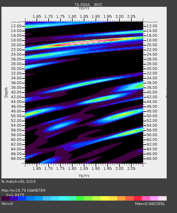
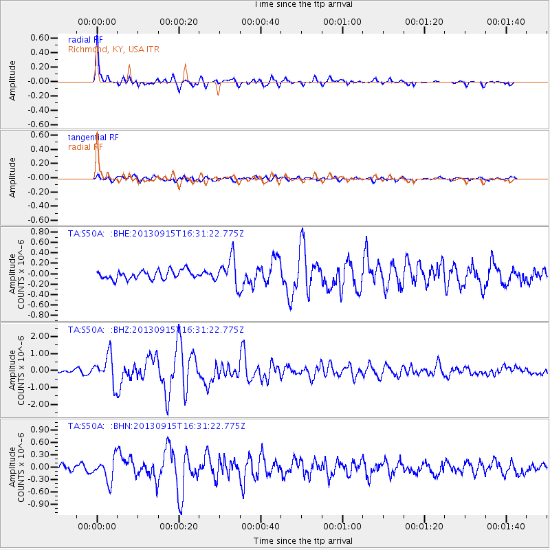
S50A Richmond, KY, USA - Earthquake Result Viewer

Earthquake location: Andreanof Islands, Aleutian Is.
Earthquake latitude/longitude: 51.6/-174.7
Earthquake time(UTC): 2013/09/15 (258) 16:21:37 GMT
Earthquake Depth: 24 km
Earthquake Magnitude: 6.1 MWW, 5.7 MI, 5.7 ML, 6.0 MWB, 6.1 MWC, 6.1 MWW
Earthquake Catalog/Contributor: NEIC PDE/NEIC COMCAT
Network: TA USArray Transportable Network (new EarthScope stations)
Station: S50A Richmond, KY, USA
Lat/Lon: 37.68 N/84.40 W
Elevation: 300 m
Distance: 61.8 deg
Az: 64.218 deg
Baz: 314.909 deg
Ray Param: 0.060625672
Estimated Moho Depth: 18.75 km
Estimated Crust Vp/Vs: 1.85
Assumed Crust Vp: 6.476 km/s
Estimated Crust Vs: 3.505 km/s
Estimated Crust Poisson's Ratio: 0.29
Radial Match: 91.5315 %
Radial Bump: 370
Transverse Match: 64.29252 %
Transverse Bump: 400
SOD ConfigId: 626651
Insert Time: 2014-04-18 17:33:21.425 +0000
GWidth: 2.5
Max Bumps: 400
Tol: 0.001

Signal To Noise

ChannelStoNSTALTA
TA:S50A: :BHZ:20130915T16:31:22.775Z9.1813998.617297E-79.385603E-8
TA:S50A: :BHN:20130915T16:31:22.775Z3.96593072.914439E-77.348689E-8
TA:S50A: :BHE:20130915T16:31:22.775Z3.3800232.7809958E-78.227742E-8
Arrivals
Ps2.6 SECOND
PpPs7.9 SECOND
PsPs/PpSs10 SECOND