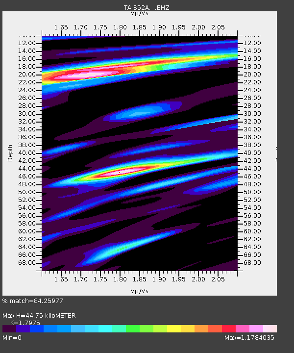
S52A Salyersville, KY, USA - Earthquake Result Viewer
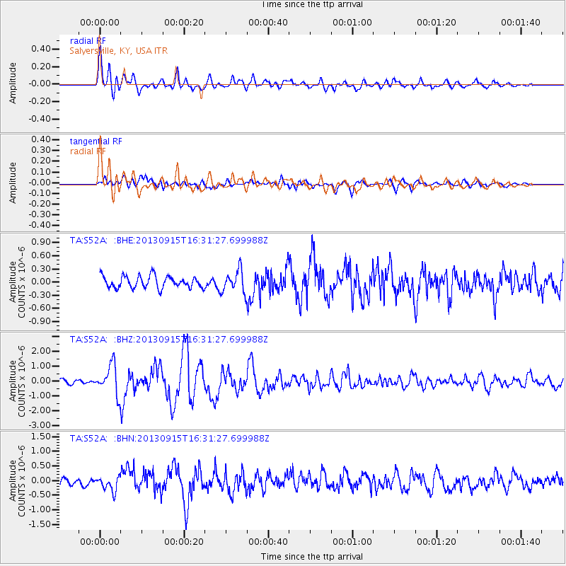
Earthquake location: Andreanof Islands, Aleutian Is.
Earthquake latitude/longitude: 51.6/-174.7
Earthquake time(UTC): 2013/09/15 (258) 16:21:37 GMT
Earthquake Depth: 24 km
Earthquake Magnitude: 6.1 MWW, 5.7 MI, 5.7 ML, 6.0 MWB, 6.1 MWC, 6.1 MWW
Earthquake Catalog/Contributor: NEIC PDE/NEIC COMCAT
Network: TA USArray Transportable Network (new EarthScope stations)
Station: S52A Salyersville, KY, USA
Lat/Lon: 37.68 N/83.08 W
Elevation: 367 m
Distance: 62.5 deg
Az: 63.377 deg
Baz: 315.321 deg
Ray Param: 0.06014024
Estimated Moho Depth: 44.75 km
Estimated Crust Vp/Vs: 1.80
Assumed Crust Vp: 6.476 km/s
Estimated Crust Vs: 3.603 km/s
Estimated Crust Poisson's Ratio: 0.28
Radial Match: 84.25977 %
Radial Bump: 400
Transverse Match: 68.80125 %
Transverse Bump: 400
SOD ConfigId: 626651
Insert Time: 2014-04-18 17:33:25.871 +0000
GWidth: 2.5
Max Bumps: 400
Tol: 0.001

Signal To Noise

ChannelStoNSTALTA
TA:S52A: :BHZ:20130915T16:31:27.699988Z6.82556151.0132771E-61.484533E-7
TA:S52A: :BHN:20130915T16:31:27.699988Z2.34690212.3969895E-71.0213419E-7
TA:S52A: :BHE:20130915T16:31:27.699988Z1.86739472.5397117E-71.3600294E-7
Arrivals
Ps5.8 SECOND
PpPs18 SECOND
PsPs/PpSs24 SECOND