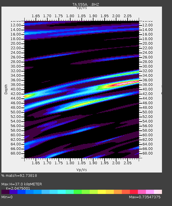
S55A Lewisburg, WV, USA - Earthquake Result Viewer
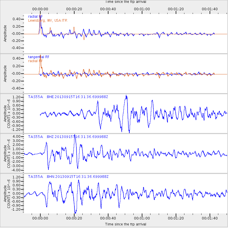
Earthquake location: Andreanof Islands, Aleutian Is.
Earthquake latitude/longitude: 51.6/-174.7
Earthquake time(UTC): 2013/09/15 (258) 16:21:37 GMT
Earthquake Depth: 24 km
Earthquake Magnitude: 6.1 MWW, 5.7 MI, 5.7 ML, 6.0 MWB, 6.1 MWC, 6.1 MWW
Earthquake Catalog/Contributor: NEIC PDE/NEIC COMCAT
Network: TA USArray Transportable Network (new EarthScope stations)
Station: S55A Lewisburg, WV, USA
Lat/Lon: 37.77 N/80.50 W
Elevation: 647 m
Distance: 63.9 deg
Az: 61.665 deg
Baz: 316.12 deg
Ray Param: 0.05925647
Estimated Moho Depth: 37.0 km
Estimated Crust Vp/Vs: 2.05
Assumed Crust Vp: 6.159 km/s
Estimated Crust Vs: 3.008 km/s
Estimated Crust Poisson's Ratio: 0.34
Radial Match: 92.73818 %
Radial Bump: 371
Transverse Match: 77.53318 %
Transverse Bump: 400
SOD ConfigId: 626651
Insert Time: 2014-04-18 17:33:33.569 +0000
GWidth: 2.5
Max Bumps: 400
Tol: 0.001

Signal To Noise

ChannelStoNSTALTA
TA:S55A: :BHZ:20130915T16:31:36.699988Z11.6540291.4283411E-61.22562E-7
TA:S55A: :BHN:20130915T16:31:36.699988Z2.6930153.7155985E-71.3797168E-7
TA:S55A: :BHE:20130915T16:31:36.699988Z3.21085213.400857E-71.0591759E-7
Arrivals
Ps6.5 SECOND
PpPs18 SECOND
PsPs/PpSs24 SECOND