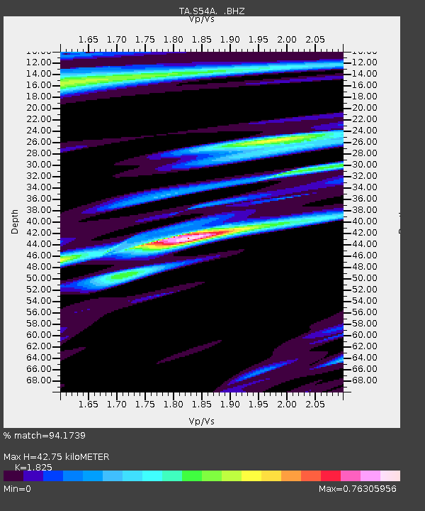
S54A Dingess, Beckley, WV, USA - Earthquake Result Viewer
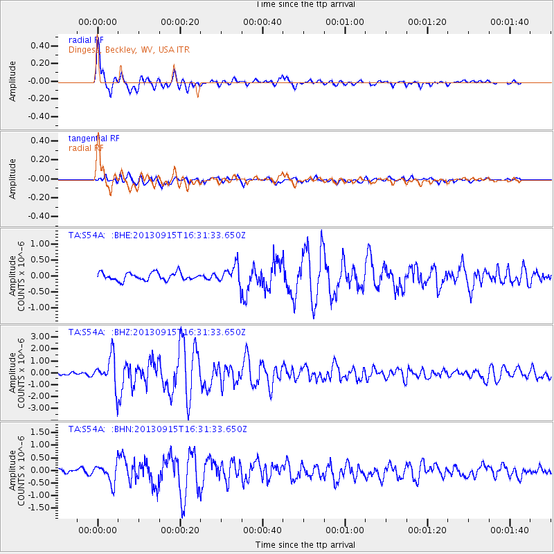
Earthquake location: Andreanof Islands, Aleutian Is.
Earthquake latitude/longitude: 51.6/-174.7
Earthquake time(UTC): 2013/09/15 (258) 16:21:37 GMT
Earthquake Depth: 24 km
Earthquake Magnitude: 6.1 MWW, 5.7 MI, 5.7 ML, 6.0 MWB, 6.1 MWC, 6.1 MWW
Earthquake Catalog/Contributor: NEIC PDE/NEIC COMCAT
Network: TA USArray Transportable Network (new EarthScope stations)
Station: S54A Dingess, Beckley, WV, USA
Lat/Lon: 37.80 N/81.31 W
Elevation: 636 m
Distance: 63.4 deg
Az: 62.159 deg
Baz: 315.845 deg
Ray Param: 0.059561413
Estimated Moho Depth: 42.75 km
Estimated Crust Vp/Vs: 1.83
Assumed Crust Vp: 6.159 km/s
Estimated Crust Vs: 3.375 km/s
Estimated Crust Poisson's Ratio: 0.29
Radial Match: 94.1739 %
Radial Bump: 400
Transverse Match: 76.297 %
Transverse Bump: 400
SOD ConfigId: 626651
Insert Time: 2014-04-18 17:33:38.798 +0000
GWidth: 2.5
Max Bumps: 400
Tol: 0.001

Signal To Noise

ChannelStoNSTALTA
TA:S54A: :BHZ:20130915T16:31:33.650Z10.4339511.37324E-61.3161267E-7
TA:S54A: :BHN:20130915T16:31:33.650Z3.40842563.851241E-71.1299179E-7
TA:S54A: :BHE:20130915T16:31:33.650Z2.5172922.989138E-71.187442E-7
Arrivals
Ps6.0 SECOND
PpPs19 SECOND
PsPs/PpSs25 SECOND