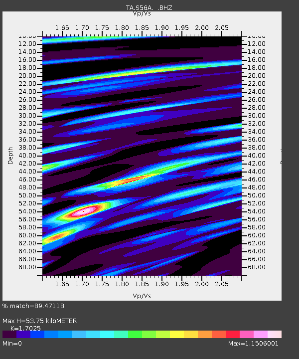
S56A Natural Bridge, VA, USA - Earthquake Result Viewer

Earthquake location: Andreanof Islands, Aleutian Is.
Earthquake latitude/longitude: 51.6/-174.7
Earthquake time(UTC): 2013/09/15 (258) 16:21:37 GMT
Earthquake Depth: 24 km
Earthquake Magnitude: 6.1 MWW, 5.7 MI, 5.7 ML, 6.0 MWB, 6.1 MWC, 6.1 MWW
Earthquake Catalog/Contributor: NEIC PDE/NEIC COMCAT
Network: TA USArray Transportable Network (new EarthScope stations)
Station: S56A Natural Bridge, VA, USA
Lat/Lon: 37.68 N/79.57 W
Elevation: 449 m
Distance: 64.5 deg
Az: 61.143 deg
Baz: 316.462 deg
Ray Param: 0.05887701
Estimated Moho Depth: 53.75 km
Estimated Crust Vp/Vs: 1.70
Assumed Crust Vp: 6.419 km/s
Estimated Crust Vs: 3.77 km/s
Estimated Crust Poisson's Ratio: 0.24
Radial Match: 89.47118 %
Radial Bump: 400
Transverse Match: 63.342907 %
Transverse Bump: 400
SOD ConfigId: 626651
Insert Time: 2014-04-18 17:33:42.995 +0000
GWidth: 2.5
Max Bumps: 400
Tol: 0.001

Signal To Noise

ChannelStoNSTALTA
TA:S56A: :BHZ:20130915T16:31:40.499976Z11.8628441.4815796E-61.2489244E-7
TA:S56A: :BHN:20130915T16:31:40.499976Z3.23430254.2042717E-71.2999006E-7
TA:S56A: :BHE:20130915T16:31:40.499976Z3.33586845.68121E-71.7030678E-7
Arrivals
Ps6.1 SECOND
PpPs22 SECOND
PsPs/PpSs28 SECOND