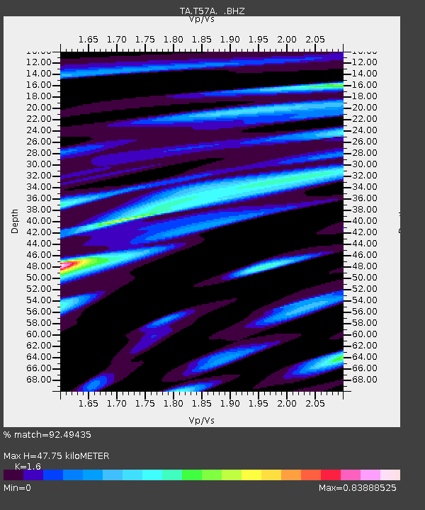
T57A Hurt, VA, USA - Earthquake Result Viewer
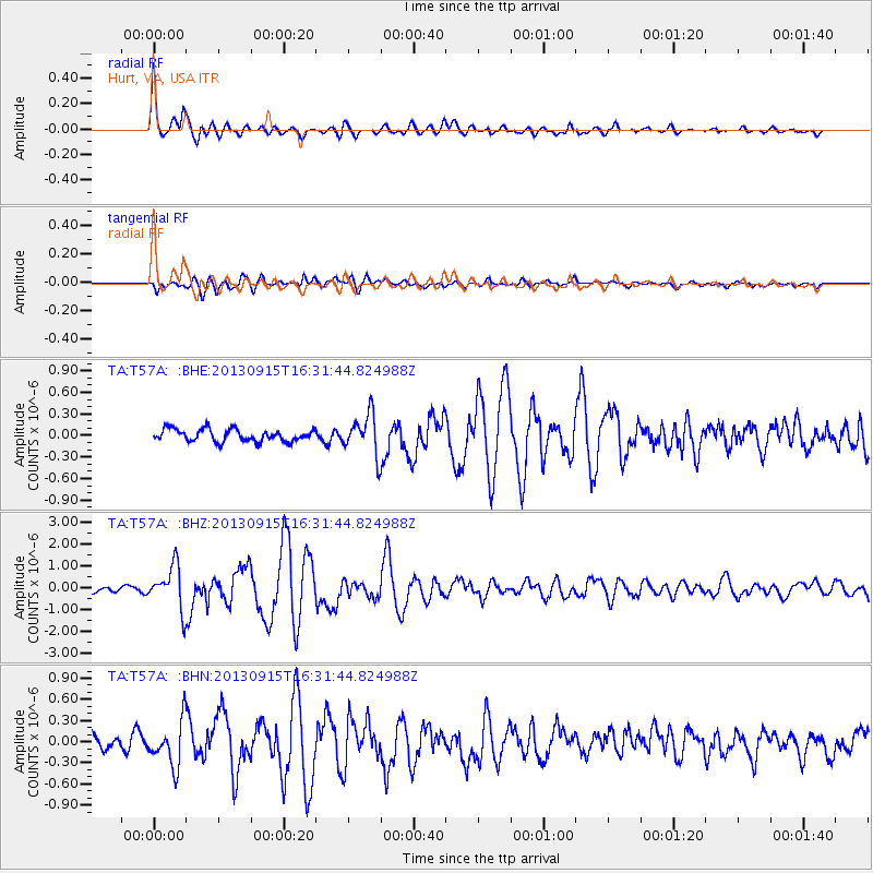
Earthquake location: Andreanof Islands, Aleutian Is.
Earthquake latitude/longitude: 51.6/-174.7
Earthquake time(UTC): 2013/09/15 (258) 16:21:37 GMT
Earthquake Depth: 24 km
Earthquake Magnitude: 6.1 MWW, 5.7 MI, 5.7 ML, 6.0 MWB, 6.1 MWC, 6.1 MWW
Earthquake Catalog/Contributor: NEIC PDE/NEIC COMCAT
Network: TA USArray Transportable Network (new EarthScope stations)
Station: T57A Hurt, VA, USA
Lat/Lon: 37.00 N/79.25 W
Elevation: 230 m
Distance: 65.1 deg
Az: 61.457 deg
Baz: 316.784 deg
Ray Param: 0.05844704
Estimated Moho Depth: 47.75 km
Estimated Crust Vp/Vs: 1.60
Assumed Crust Vp: 6.419 km/s
Estimated Crust Vs: 4.012 km/s
Estimated Crust Poisson's Ratio: 0.18
Radial Match: 92.49435 %
Radial Bump: 395
Transverse Match: 80.79705 %
Transverse Bump: 400
SOD ConfigId: 626651
Insert Time: 2014-04-18 17:34:33.221 +0000
GWidth: 2.5
Max Bumps: 400
Tol: 0.001

Signal To Noise

ChannelStoNSTALTA
TA:T57A: :BHZ:20130915T16:31:44.824988Z6.4997029.799534E-71.5076897E-7
TA:T57A: :BHN:20130915T16:31:44.824988Z2.68495633.091332E-71.15135286E-7
TA:T57A: :BHE:20130915T16:31:44.824988Z3.3097642.793159E-78.439149E-8
Arrivals
Ps4.7 SECOND
PpPs18 SECOND
PsPs/PpSs23 SECOND